Auckland Islands
| Auckland Islands | ||
|---|---|---|
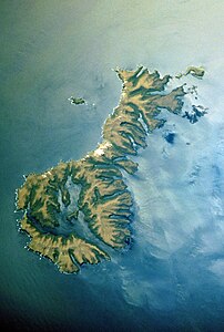
| NASA image of the Auckland Islands | ||
| Waters | South pacific | |
| Geographical location | 50 ° 44 ′ S , 166 ° 5 ′ E | |
|
|
||
| Number of islands | 7th | |
| Main island | Auckland Island | |
| Total land area | 568.16 km² | |
| Residents | uninhabited | |
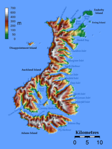
| Topographic map | ||
The Auckland Islands or officially Auckland Islands ( māori : Motu Maha ) are a group of sub-Antarctic islands that have belonged to New Zealand since 1863 . The mountainous and uninhabited archipelago of volcanic origin was declared a World Heritage Site by UNESCO in 1998 .
geography
The Auckland Islands, as the remains of two former volcanoes , are located 465 km south-southeast of the port city of Bluff ( South Island of New Zealand ) between 50 ° 26 'and 50 ° 56' south latitude and 165 ° 52 'and 166 ° 22' east longitude.
The archipelago, which has a contiguous total area of 568.16 km², consists of:
- the main island of Auckland Island , which measures about 40 km in length and around 12 km at its widest point. With 458.89 km² it is by far the largest island.
- Adams Island , as the second largest island,
- Enderby Island , as the third largest island
- Disappointment Island, 4 km further west, as the fourth largest island, and other islands, e.g. B.
- Rose Island , Ewing Island and many other little ones.
The highest point of the archipelago, the 705 m high Mount Dick , is located on Adams Island. The westernmost point of the archipelago, Cape Lovitt , is also the westernmost point of New Zealand.
climate
The first meteorological record of the Auckland Islands was not made until 1941, when five coastal watch stations were established on the islands. In March 1945, however, the last station was dismantled. Thereafter, measurement data were taken from the sea area of Campbell Island .
The climate of the Auckland Islands is characterized by strong, almost constant westerly winds. The rainfall is usually moderate at 1000–1500 mm pa, although it rains for over 300 days a year. The annual mean temperatures are around 8 ° C , in summer usually around 10–16 ° C and in winter, slightly different, at 4–10 ° C.
history
exploration
In 1998, the remains of a Polynesian settlement were found on Enderby Island by Professor Atholl John Anderson . After investigations using the radiocarbon method , it is assumed that the islands were inhabited between the 12th and 13th centuries. The find is still the southernmost of all Polynesian settlements.
When Captain Abraham Bristow sailed for the islands on August 18, 1806 with his whaling ship Ocean and discovered them for the Europeans, they were uninhabited. He named the archipelago Lord Auckland's in honor of his father's friend William Eden, 1st Baron Auckland . He named Enderby Island after his client Samuel Enderby , owner of the British whaling company Samuel Enderby & Sons . In 1807 Great Britain laid claim to the archipelago. Seal catchers soon came and set up their stations on the islands, but by 1812 the stocks of seals were so depleted that the hunters gave up their settlements again.
In March 1840, the researcher Jules Dumont d'Urville visited the Auckland Islands for nine days. James Clark Ross followed him in November 1840 . He had the islands explored more thoroughly. Botanists David Lyall and Joseph Dalton Hooker collected over 80 plants for their research. They also left sheep, rabbits and chickens and planted various vegetables and garden crops for testing purposes.
In October 1874, German explorers landed in Terror Cove in Port Ross Bay . The aim of their expedition was to be able to observe and explore the transit of Venus . They stayed for six months. During the Second World War , from 1941 to 1945, the Auckland Islands were equipped with five coast guard stations to monitor the sea routes.
Attempt to colonize
In 1841 an attempt was made to colonize the islands. A group of 150 Māori from the Chatham Islands settled on the islands. In October 1842 another 30 Māori came , among them the Chief Matioro with 30 Moriori slaves.
In December 1849, 150 British settlers tried their luck in Port Ross Bay . But they found the land of around 60 Māori and Moriori living there already largely divided. In January 1850 they founded their Hardwicke settlement , but gave up after only two years and nine months due to inhospitable living conditions. The initiator of the settlement project was the Briton Charles Enderby . The last surviving 19 Māori and 11 Moriori gave up in 1854. Although the Auckland Islands were considered uninhabitable, Great Britain assigned them to its New Zealand colony in 1863 .
Shipping accidents
The Auckland Islands were known for some spectacular ship accidents in the 19th century . Eight of them are known. Since basalt cliffs rise up to 365 m on the western side of Auckland Island and it rains on average 27 days a month, with winds usually more than 60 km / h, sailing ships are in great danger when they visit the islands got too close.
- 1864 - The Minerva of Leith sank off the Auckland Islands. Four survivors were rescued on March 25, 1865.
- January 1864 - The Grafton ran aground in Carnley Harbor. The captain and four crew members survived and spent 18 months on the islands.
- May 1864 - The Invercauld broke on the western cliffs of Auckland Island. 19 out of 25 sailors were able to save themselves, but only three survived the following weeks until they were rescued.
- May 1866 - General Grant drifted to the western cliffs of Auckland Island. 68 passengers drowned, 15 came ashore, but only 10 people survived the accident.
- March 1887 - Derry Castle ran out onto a reef on Enderby Island. There were only 8 survivors.
- March 1891 - The Compadre wrecked the Auckland Islands with 15 survivors.
- March 1905 - The Anjou ran onto a reef on the west coast of Auckland Island near Cape Bristow. All survived.
- March 1907 - The Dundonald crashed on the coast of Disappointment Island, drowning 12 crew members.
Due to the remoteness of the islands and the experience of shipwreck survivors in the Auckland areas, huts with provisions for survivors were established in 1867 at three locations, Erebus Cove, Saddle Hill and Musgrave's Hut in Carnley Harbor.
Establishment of marine protection zones
In 1993, the Auckland Islands Marine Mammal Sanctuary , a 560,564 hectare area around the Auckland Islands, was established as a marine mammal protection zone. In 2003, the Auckland Islands-Motu Maha Marine Reserve was established , a 498,000 hectare marine reserve . Both protection zones thus extend around 12 nautical miles around the archipelago.
today
Today the islands are still uninhabited, but are occasionally visited by scientists and a strictly regulated number of tourists.
Wildlife
The Auckland Islands were the former focus of distribution of the now exterminated Auckland saws ( Mergus australis , exterminated in 1901). Located on the islands are among others the endangered yellow-eyed penguin ( Megadyptes antipodes ), the yellow-crowned parakeet ( Cyanoramphus auriceps auriceps ) and a subspecies of goat parakeet ( Cyanoramphus novaezelandiae novaezelandiae ). The flightless Auckland duck ( Anas aucklandica ) and the Auckland rail ( Lewinia muelleri ) were almost wiped out by introduced dogs and cats and can only be found on some of the smaller islands. The Auckland shark , an endemic species of cormorant in this group of islands, is also considered endangered .
Only two indigenous mammal species are found on the archipelago: the New Zealand sea lion ( Phocarctos hookeri ) and the New Zealand fur seal ( Arctocephalus forsteri ).
Flora
Mainly the South Island ironwood ( Metrosideros umbellata ), also known as "Southern Rātā", grows on the island .
See also
Web links
- Sub-Antarctic Islands - The Auckland Islands. Te Ara - the Encyclopedia of New Zealand, accessed July 30, 2012 .
- Auckland Islands. Department of Conservation, accessed July 30, 2012 .
- Topomap - Auckland Islands - 1: 50,000. (JPG) Land Information New Zealand , accessed July 30, 2012 .
- Murihiku expeditions. Paul Hulford, Auckland, accessed July 31, 2012 .
Individual evidence
- ↑ Federal Office for Cartography and Geodesy (Ed.) : List of names of states and their derivatives in German with an appendix: List of names of selected non-independent areas . March 2012, p. 17 (20 pp., Online [PDF; 288 kB ; accessed on August 25, 2019] Publication of the Standing Committee on Geographical Names (StAGN)).
- ↑ Decision - 22COM VIII.A.1 - Inscription: New Zealand Sub-Antarctic Islands (New Zealand) Id. No: 877. UNESCO, accessed on August 3, 2012 (English).
- ↑ a b Map of the Auckland Islands . Department of Conservation , accessed August 25, 2019 .
- ↑ Auckland Islands . Department of Conservation , accessed July 30, 2012 .
- ↑ a b JF de Lisle: The Climate of the Auckland Islands, Campbell Island and Maquarie Island . In: Ecology of the Subantarctic Islands . 1964, p. 37–44 (English, held at the symposium: “The ecology of the Subantarctic Islands of New Zealand”).
- ↑ Ken Scadden: Auckland Islands. (No longer available online.) Yellow-eyed Penguin Trust, archived from the original on Aug. 8, 2012 ; accessed on August 8, 2012 (English, original website no longer available).
- ↑ a b c Historical Timeline of the Auckland Islands. (No longer available online.) Murihiku Expeditions - Paul Hulford, Auckland, archived from the original on July 23, 2011 ; accessed on July 31, 2012 .
- ↑ Ken Scadden: Shipwreck sites, Auckland Islands. Te Ara - the Encyclopedia of New Zealand, accessed July 31, 2012 .


