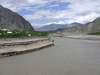
Avarskoye Koisu
|
Avarskoje Koisu Аварское Койсу, Джурмут (Jurmut) |
||
| Data | ||
| Water code | RU : 07030000112109300000728 | |
| location | Dagestan ( Russia ) | |
| River system | Sulak | |
| Drain over | Sulak → Caspian Sea | |
| source |
Guton Ridge ( Greater Caucasus ) 41 ° 52 ′ 10 ″ N , 46 ° 45 ′ 25 ″ E |
|
| Source height | 2740 m | |
| Association with |
Andijskoje Koisu zum Sulak Coordinates: 42 ° 47 ′ 27 " N , 46 ° 47 ′ 46" E 42 ° 47 ′ 27 " N , 46 ° 47 ′ 46" E |
|
| Mouth height | 355 m | |
| Height difference | 2385 m | |
| Bottom slope | 13 ‰ | |
| length | 178 km | |
| Catchment area | 7660 km² | |
| Drain |
MQ |
95 m³ / s |
| Right tributaries | Karakoisu | |
| Reservoirs flowed through | Irganaiskoje reservoir | |
|
Avarskoje Koisu (Аварское Койсу) in the catchment area of the Sulak |
||
The Avarskoje Koisu ( Russian Аварское Койсу , in the upper reaches: Джурмут (Dschurmut)) is the right source river of the Sulak in the Russian Republic of Dagestan .
The Avarskoje Koisu arises in the south of Dagestan. It flows mainly in a northerly direction. The most important tributaries of the Avarskoje Koisu are the Karakoisu from the right and its tributary Kasikumuchskoje Koisu . Finally he meets the Andijskoje Koisu coming from the west and unites with him to form Sulak.
The Avarskoye Koisu has a length of 178 km. It drains an area of 7660 km² in the east of the Greater Caucasus . It is mainly fed by the snowmelt . The mean discharge is 95 m³ / s.
The river has been used for rafting , at least in the past . Some of the river water is diverted for irrigation purposes .
The Russian -Turkish name of the river ("Avar Koisu") refers to the Avars who settle in its catchment area , as does the name of the other Sulak source river, Andijskoje Koisu, to the Andean peoples who predominantly live there .
Use of hydropower
There are two dams along the river, each with an attached hydropower plant. The Irganai hydropower plant is fed by the 18 km² Irganaiskoje reservoir .
The hydropower plants in the downstream direction:
| Surname | completion position |
Power in MW |
Annual output in GWh |
Fall height in m |
Congestion destination in m |
Storage space in million m³ |
|---|---|---|---|---|---|---|
| Gozatl | 2014 | 100 | 350 | 69 | 665 | 48.1 |
| Irganai | 2001 | 400 | 1230 | 168 | 540 | 705 |
Individual evidence
- ↑ a b c d Article Koisu in the Great Soviet Encyclopedia (BSE) , 3rd edition 1969–1978 (Russian)
- ↑ a b Avarskoje Koisu in the State Water Register of the Russian Federation (Russian)
- ↑ rushydro.ru


