Sulak (river)
|
Sulak Сула́к |
||
|
|
||
| Data | ||
| Water code | RU : 07030000112109300000254 | |
| location | Republic of Dagestan ( Russia ) | |
| River system | Sulak | |
| confluence | of Andijskoje Koisu and Avarskoje Koisu 42 ° 47 ′ 28 ″ N , 46 ° 47 ′ 45 ″ E |
|
| muzzle |
Caspian Sea Coordinates: 43 ° 15 ′ 16 " N , 47 ° 32 ′ 56" E 43 ° 15 ′ 16 " N , 47 ° 32 ′ 56" E |
|
| Mouth height | 28 m below sea level | |
| Height difference | 383 m | |
| Bottom slope | 2.7 ‰ | |
| length | 144 km (according to other sources 169 km) | |
| Catchment area | 15,200 km² | |
| Outflow location: 123 km above the mouth |
MQ |
176 m³ / s |
| Left tributaries | Aktash | |
| Reservoirs flowed through | Tschirkei dam | |
| Medium-sized cities | Kisiljurt | |
|
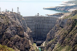
Tschirkei dam on Sulak |
||
|
Original catchment area of the Sulak (Сула́к). In addition, the Aktasch and Aksai rivers are channeled to the Sulak. |
||
The Sulak ( Russian Сула́к ) is a 144 km long tributary of the Caspian Sea in the Northeast Caucasus ( Russia ).
course
The Sulak arises in the northeastern foothills of the Greater Caucasus at an altitude of 355 m from the Andijskoje Koisu from the left (length 144 km, without its two short source rivers) and the Avarskoje Koisu (178 km) from the right. The total length with the latter is 322 kilometers. In the (Russian) name of the source rivers reflects the main settlement of the flowed through areas by different Northeast Caucasian peoples, the Andean peoples and the Avars .
After the confluence, the Sulak flows for about 20 kilometers through the Sulak main canyon , which is more than 1500 meters deep , the walls of which rise up to 800 meters in places almost vertically above the river, and the Achetlinskoje Gorge . The river that used to rush in this area is now in the backwater area of the Tschirkei dam . After the valley widening around Tschirkei , which is occupied by the aforementioned reservoir, follows the Little Sulak Canyon , which is almost 1000 meters deep , before the river reaches the plain of the Caucasus foothills near the town of Kisiljurt .
In this intensively agriculturally used area, the Sulak soon turns from the hitherto north to east, meanders and forms river arms in a wide, terraced valley until it finally flows into the Caspian Sea not far from the urban-type Sulak settlement named after it .
Apart from its headwaters, the Sulak has no significant natural tributaries. The two rivers Aktasch and Aksai are fed to the Sulak via canals. The Sulak flows in its entire course through the territory of the Republic of Dagestan .
Hydrography
The catchment area of the Sulak covers 15,200 km². Near the mouth, the river is a good 200 meters wide and over two meters deep; the flow velocity here is 1.0 m / s.
The mean water flow in the middle course, 123 kilometers above the mouth, is 176 m³ / s. The river is mainly fed by melt water from the high altitudes of the Caucasus, so that it carries floods from April to September with a maximum in June to July. During this time, the suspended matter concentration can reach 45 kg / m³, one hundred times the average.
Economy and Infrastructure
The Sulak is not navigable.
Its water is however intense for irrigation and water supply as the Republic capital Makhachkala and nearby Kaspijsk used, including from 1921 to 1923 the October Revolution channel ( канал им. Октябрьской Революции / channel in. Oktjabrskoi Revolyutsii ) the first major construction project of the newly established Dagestani ASSR came into being. The 70-kilometer-long canal connects the Sulak near today's city of Kisiljurt with Makhachkala and was later replaced by pipelines, etc. a. starting from the Miatli reservoir, added.
The river plays an important role in supplying electricity to Dagestan and the surrounding regions. The Dagestani branch of RusHydro operates a cascade of hydropower plants on the Sulak and its source rivers :
| Surname | Power ( MW ) |
Wall / dam height (m) |
construction time |
|---|---|---|---|
| Gunib * | 15th | 73 | 1995-2005 |
| Gergebil * | 17.8 | 70 | 1930-1956 |
| Tschirkei | 1000 | 233 | 1964-1977 |
| Miatli | 220 | 80 | 1975-1987 |
| Tschirjurt 1 | 72 | 37.5 | 1954-1961 |
| Tschirjurt 2 | 9 | - | 1959-1964 |
| Bawtugai ** | 0.6 | - | around 2000 |
| Gelbach | 44 | - | 2004-2007 |
Notes: sorted by order downstream; * on the Karakoisu, tributary of the Avarskoye Koisu; ** experimental small power plant
As of 2008, the construction of a further ten hydropower plants on the source rivers Andijskoje Koisu (Agwali, Zumada, Botlich, Incho, Tantari), Avarskoje Koisu (Avarskaya, Sovetskaya 1 and 2) and Karakoisu (Magar, Kurmi) is planned or projected.
Individual evidence
- ↑ a b c Article Sulak in the Great Soviet Encyclopedia (BSE) , 3rd edition 1969–1978 (Russian)
- ↑ a b Sulak in the State Water Directory of the Russian Federation (Russian)
- ↑ a b Igor Zonn: Kaspijskaja ėncyklopedija . Meždunarodnye otnošenija, Moscow 2004 ( Caspian Encyclopedia ; Russian).
- ↑ a b hydropower plants in Dagestan on the operator website (Russian)

