Béthune (river)
| Bethune | ||
|
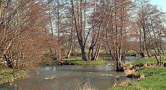
The river at Saint-Aubin-le-Cauf |
||
| Data | ||
| Water code | FR : G2-0200 | |
| location | France , Normandy region | |
| River system | Arques | |
| Drain over | Arques → English Channel | |
| source | in the municipality of Gaillefontaine 49 ° 38 ′ 6 ″ N , 1 ° 37 ′ 41 ″ E |
|
| Source height | approx. 204 m | |
| muzzle | Union with the Varenne and Eaulne rivers in the municipality of Arques-la-Bataille and formation of the Arques River Coordinates: 49 ° 53 ′ 27 ″ N , 1 ° 7 ′ 47 ″ E 49 ° 53 ′ 27 ″ N , 1 ° 7 ′ 47 ″ O |
|
| Mouth height | approx. 4 m | |
| Height difference | approx. 200 m | |
| Bottom slope | approx. 3.3 ‰ | |
| length | approx. 61 km | |
| Small towns | Neufchâtel-en-Bray | |
The Béthune is a river in France that runs in the Seine-Maritime department in the Normandy region . It rises in the municipality of Gaillefontaine and generally drains in a north-westerly direction through the landscape of the Pays de Bray . After a stretch of river of about 61 kilometers, the Béthune joins the Varenne and Eaulne rivers in the municipality of Arques-la-Bataille , thus forming the Arques River , which flows six kilometers further into the English Channel .
Places on the river
- Gaillefontaine
- Neufchâtel-en-Bray
- Mesnières-en-Bray
- Bures-en-Bray
- Osmoy-Saint-Valery
- Saint-Vaast-d'Équiqueville
- Dampierre-Saint-Nicolas
- Saint-Aubin-le-Cauf
- Arques-la-Bataille
Web links
Commons : Béthune - collection of images, videos and audio files
Remarks
- ↑ a b geoportail.fr (1: 16,000)
- ↑ a b The information on the length of the river is based on the data of the Arques river from SANDRE (French), accessed on February 7, 2010, as these obviously contain the course of the Béthune river. The length given there was therefore reduced by that of the Arques (six kilometers).
