
Dampierre-Saint-Nicolas
| Dampierre-Saint-Nicolas | ||
|---|---|---|
.svg)
|
|
|
| region | Normandy | |
| Department | Seine-Maritime | |
| Arrondissement | Dieppe | |
| Canton | Dieppe-2 | |
| Community association | Falaises du Talou | |
| Coordinates | 49 ° 52 ′ N , 1 ° 12 ′ E | |
| height | 14-136 m | |
| surface | 3.94 km 2 | |
| Residents | 472 (January 1, 2017) | |
| Population density | 120 inhabitants / km 2 | |
| Post Code | 76510 | |
| INSEE code | 76210 | |

Dampierre-Saint-Nicolas is a commune in the French department of Seine-Maritime in the region Normandy (before 2016 Haute-Normandie ). It belongs to the Arrondissement Dieppe and the canton Dieppe-2 (until 2015 canton Envermeu ). The inhabitants are called Dampierrois .
geography
Dampierre-Saint-Nicolas is located about 18 kilometers southeast of Dieppe on the Béthune . Dampierre-Saint-Nicolas is surrounded by the neighboring communities of Saint-Aubin-le-Cauf in the north and west, Saint-Nicolas-d'Aliermont in the north and northeast, Saint-Jacques-d'Aliermont in the east, Meulers in the southeast and Saint- Germain-d'Étables to the south and southwest.
Population development
| year | 1962 | 1968 | 1975 | 1982 | 1990 | 1999 | 2006 | 2013 |
| Residents | 333 | 396 | 509 | 510 | 515 | 483 | 510 | 522 |
| Source: Cassini and INSEE | ||||||||
Attractions
- Saint-Pierre-et-Saint-Paul church
- Lock and gate

Saint-Pierre-et-Saint-Paul church
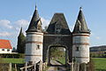
Gate to the castle


Personalities
- Marc-Antoine de Dampierre (1676–1756), composer and horn player
Web links
Commons : Dampierre-Saint-Nicolas - Collection of images, videos and audio files