Beauvoir-en-Lyons
| Beauvoir-en-Lyons | ||
|---|---|---|
|
|
||
| region | Normandy | |
| Department | Seine-Maritime | |
| Arrondissement | Dieppe | |
| Canton | Gournay-en-Bray | |
| Community association | 4 Rivières | |
| Coordinates | 49 ° 30 ′ N , 1 ° 35 ′ E | |
| height | 129-231 m | |
| surface | 33.29 km 2 | |
| Residents | 617 (January 1, 2017) | |
| Population density | 19 inhabitants / km 2 | |
| Post Code | 76220 | |
| INSEE code | 76067 | |
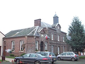
 Town hall (Mairie) of Beauvoir-en-Lyons |
||
Beauvoir-en-Lyons is a French village with 617 inhabitants (as of January 1 2017) in the department of Seine-Maritime in the region Normandy . It belongs to the Arrondissement Dieppe and is part of the canton of Gournay-en-Bray (until 2015: canton of Argueil ).
geography
Beauvoir-en-Lyons is about 36 kilometers east-northeast of Rouen . Beauvoir-en-Lyons is surrounded by the neighboring communities of Fry in the north and north-west, Hodeng-Hodenger in the north, Brémontier-Merval in the east and north-east, Elbeuf-en-Bray in the east, Avesnes-en-Bray in the east and south-east, Bosc- Hyons in the south-east, Bézancourt in the south, La Feuillie in the west and south-west and Le Mesnil-Lieubray in the north-west.
The National Route 31 runs through the municipality .
Population development
| year | 1962 | 1968 | 1975 | 1982 | 1990 | 1999 | 2006 | 2013 |
| Residents | 669 | 561 | 539 | 464 | 463 | 473 | 556 | 629 |
| Source: Cassini and INSEE | ||||||||
Attractions
- Saint-Nicolas church from the 13th century, current building from the 18th century
- Chapel of the former Saint-Laurent-en-Lyons priory
- Remains of the castle from the 12th century
- Bos-Hyons Castle in Routieux
- Forest of Lyons

