
Saint-Aubin-le-Cauf
| Saint-Aubin-le-Cauf | ||
|---|---|---|
.svg)
|
|
|
| region | Normandy | |
| Department | Seine-Maritime | |
| Arrondissement | Dieppe | |
| Canton | Dieppe-2 | |
| Community association | Falaises du Talou | |
| Coordinates | 49 ° 52 ' N , 1 ° 11' E | |
| height | 4-133 m | |
| surface | 10.11 km 2 | |
| Residents | 853 (January 1, 2017) | |
| Population density | 84 inhabitants / km 2 | |
| Post Code | 76510 | |
| INSEE code | 76562 | |

Saint-Aubin-le-Cauf is a municipality with 853 inhabitants (as of January 1 2017) in the French department of Seine-Maritime in the region Normandy (before 2016 Haute-Normandie ). It belongs to the Arrondissement Dieppe and the canton Dieppe-2 (until 2015 canton Envermeu ). The inhabitants are called Saint-Aubinois .
geography
Saint-Aubin-le-Cauf is located about 14 kilometers southeast of Dieppe am Béthune . Saint-Aubin-le-Cauf is surrounded by the neighboring communities of Arques-la-Bataille in the north and north-west, Saint-Nicolas-d'Aliermont in the north-east, Dampierre-Saint-Nicolas in the east and south-east, and Saint-Germain-d'Étables in the South and Martigny in the west.
Population development
| year | 1962 | 1968 | 1975 | 1982 | 1990 | 1999 | 2006 | 2013 |
| Residents | 552 | 534 | 563 | 672 | 747 | 747 | 861 | 911 |
| Source: Cassini and INSEE | ||||||||
Attractions
- Saint-Aubin church
- 18th century castle
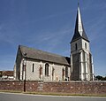
Saint-Aubin church

lock


Web links
Commons : Saint-Aubin-le-Cauf - Collection of images, videos and audio files