
Mauquenchy
| Mauquenchy | ||
|---|---|---|
|
||
| region | Normandy | |
| Department | Seine-Maritime | |
| Arrondissement | Dieppe | |
| Canton | Gournay-en-Bray | |
| Community association | 4 Rivières | |
| Coordinates | 49 ° 36 ′ N , 1 ° 28 ′ E | |
| height | 118-236 m | |
| surface | 12.64 km 2 | |
| Residents | 352 (January 1, 2017) | |
| Population density | 28 inhabitants / km 2 | |
| Post Code | 76440 | |
| INSEE code | 76420 | |
 Mauquenchy Town Hall (Mairie) |
||

Mauquenchy is a French municipality with 352 inhabitants (at January 1, 2017) in the department of Seine-Maritime in the region Normandy (before 2016 Haute-Normandie ). The municipality belongs to the Arrondissement Dieppe and the canton Gournay-en-Bray (until 2015 Forges-les-Eaux ).
geography
Mauquenchy is about 25 kilometers northeast of Rouen . Mauquenchy is surrounded by the neighboring communities Roncherolles-en-Bray in the north and east, Rouvray-Catillon in the south and south-east, Bosc-Édeline in the south and south-west, Bois-Héroult in the south-west and Bosc-Bordel in the west and north-west.
Population development
| 1962 | 1968 | 1975 | 1982 | 1990 | 1999 | 2006 | 2013 |
| 305 | 271 | 257 | 261 | 266 | 276 | 305 | 345 |
| Source: Cassini and INSEE | |||||||
Attractions
- Saint-Martin-et-Saint-Aubin church
- Rouen-Mauquenchy Hippodrome
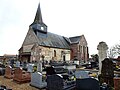
Saint-Martin-et-Saint-Aubin church

hippodrome


Web links
Commons : Mauquenchy - collection of images, videos and audio files