
Aumale (Seine-Maritime)
| Aumale | ||
|---|---|---|

|
|
|
| region | Normandy | |
| Department | Seine-Maritime | |
| Arrondissement | Dieppe | |
| Canton | Gournay-en-Bray | |
| Community association | Aumale Blangy-sur-Bresle | |
| Coordinates | 49 ° 46 ′ N , 1 ° 45 ′ E | |
| height | 106-212 m | |
| surface | 9.06 km 2 | |
| Residents | 2,024 (January 1, 2017) | |
| Population density | 223 inhabitants / km 2 | |
| Post Code | 76390 | |
| INSEE code | 76035 | |
| Website | http://www.aumale.com | |
 Town hall (Hôtel de ville) in Aumale |
||

Aumale is a commune with 2,024 inhabitants (at January 1, 2017) in the Seine-Maritime department in the region of Normandy . It belongs to the Arrondissement of Dieppe and the canton of Gournay-en-Bray .
geography
Aumale is the easternmost municipality in the Seine-Maritime department. It is located in the valley of the Bresle , 16 kilometers from Formerie and Hornoy-le-Bourg , 18 kilometers from Foucarmont and Poix-de-Picardie , 21 kilometers from Grandvilliers , 22 kilometers from Blangy-sur-Bresle and 26 kilometers from Neufchâtel-en- Bray and Forges-les-Eaux away.
Population development
| Population development | |||||||
|---|---|---|---|---|---|---|---|
| year | 1962 | 1968 | 1975 | 1982 | 1990 | 1999 | 2009 |
| Residents | 2,716 | 2,833 | 2,825 | 2,876 | 2,690 | 2,577 | 2.405 |
Attractions
- The Saint-Pierre et Saint-Paul church was rebuilt from 1508 to 1601 after being destroyed by Charles the Bold in 1472 . The side portal is attributed to Jean Goujon . The church contains stained glass windows from the 16th century and the burial place of the Dukes of Aumale .
- Saint-Pierre et Saint-Paul church in Aumale

The church in the townscape
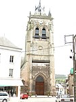
tower

North aisle
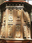
Carving in the church


- Hôtel de Ville (Town Hall), 16th century
- Hospital, 17th century
- Houses from the 16th and 17th centuries
- The Notre-Dame du Cardonnoy chapel (13th and 17th centuries)
- Le Bois-Robin Castle (17th century)
- Tower and lodge of the monks of Auchy Abbey (16th century)
Town twinning
Personalities
- Counts and Dukes of Aumale
- Alfred Le Petit (1841–1909), painter and caricaturist, born in Aumale
Web links
Commons : Aumale - collection of images, videos and audio files
- Official website of the city
- Illustration by Frans Hogenberg from 1592: Hinrich the King of Nauar, on the sixth of the moon in February, Komt zuauwen bey Daumall, Parmass laeger wie breydt and schmall, ... ( digitized version )