Beaubec-la-Rosière
| Beaubec-la-Rosière | ||
|---|---|---|

|
|
|
| region | Normandy | |
| Department | Seine-Maritime | |
| Arrondissement | Dieppe | |
| Canton | Gournay-en-Bray | |
| Community association | 4 Rivières | |
| Coordinates | 49 ° 39 ′ N , 1 ° 32 ′ E | |
| height | 108-201 m | |
| surface | 12.97 km 2 | |
| Residents | 498 (January 1, 2017) | |
| Population density | 38 inhabitants / km 2 | |
| Post Code | 76440 | |
| INSEE code | 76060 | |
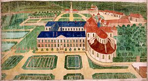
 Saint-Laurent de Beaubec Abbey |
||
Beaubec la Rosiere is a French municipality with 498 inhabitants (at January 1, 2017) in the department of Seine-Maritime in the region Normandy (before 2016 Haute-Normandie ). It belongs to the Arrondissement Dieppe and the canton Gournay-en-Bray (until 2015 canton Forges-les-Eaux ). The inhabitants are called Beaubécais .
geography
Beaubec-la-Rosière is located about 56 km southeast of Dieppe in the Pays de Bray . It borders on Compainville , Mesnil-Mauger , Roncherolles-en-Bray , Sainte-Geneviève , Saint-Saire , Serqueux and Sommery .
Population development
| year | 1962 | 1968 | 1975 | 1982 | 1990 | 1999 | 2007 | 2014 |
| Residents | 519 | 466 | 361 | 328 | 312 | 394 | 454 | 492 |
Attractions
- Chapel of Sainte-Ursule
- Stone cross from the 13th century
- Church of Sainte-Trinité in the district of Beaubec-la-Ville
Web links
Commons : Beaubec-la-Rosière - Collection of images, videos and audio files
