
Sainte-Marguerite-sur-Mer
| Sainte-Marguerite-sur-Mer | ||
|---|---|---|

|
|
|
| region | Normandy | |
| Department | Seine-Maritime | |
| Arrondissement | Dieppe | |
| Canton | Dieppe-1 | |
| Community association | Region of Dieppoise | |
| Coordinates | 49 ° 54 ' N , 0 ° 57' E | |
| height | 0-87 m | |
| surface | 5.41 km 2 | |
| Residents | 477 (January 1, 2017) | |
| Population density | 88 inhabitants / km 2 | |
| Post Code | 76119 | |
| INSEE code | 76605 | |
| Website | http://www.ste-marguerite-sur-mer.fr/ | |

Sainte-Marguerite-sur-Mer is a French commune with a population of 477 (as at 1st January 2017) in the department of Seine-Maritime in the region Normandy . Administratively it belongs to the Arrondissement Dieppe and is part of the canton Dieppe-1 (until 2015: canton Offranville ). The inhabitants are called Saint-Margueritais .
geography
Sainte-Marguerite-sur-Mer is about ten kilometers west-southwest of Dieppe on the Alabaster Coast on the English Channel . Here the Saâne flows into the English Channel. Sainte-Marguerite-sur-Mer is surrounded by the neighboring communities of Varengeville-sur-Mer in the east, Longueil in the south and Quiberville in the west.
history
In 1822 the municipality of Blancmesnil was incorporated.
Population development
| 1962 | 1968 | 1975 | 1982 | 1990 | 1999 | 2006 | 2012 |
|---|---|---|---|---|---|---|---|
| 243 | 249 | 306 | 465 | 506 | 502 | 509 | 496 |
| Source: Cassini and INSEE | |||||||
Attractions
- Sainte-Marguerite Church
- Ailly lighthouse on Cape Ailly, built in 1773, rebuilt in 1896 and 1953, monument historique since 2010
- Garden of Le Vasterival , a nine-hectare park-like area, established as a botanical garden in 1955/1957 with around 10,000 species
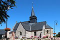
Sainte-Marguerite Church
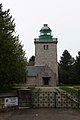
Ailly lighthouse


Personalities
- Marcelly (1882–1966), singer