
Lintot-les-Bois
| Lintot-les-Bois | ||
|---|---|---|
|
||
| region | Normandy | |
| Department | Seine-Maritime | |
| Arrondissement | Dieppe | |
| Canton | Luneray | |
| Community association | Terroir de Caux | |
| Coordinates | 49 ° 48 ' N , 1 ° 4' E | |
| height | 64-124 m | |
| surface | 2.81 km 2 | |
| Residents | 181 (January 1, 2017) | |
| Population density | 64 inhabitants / km 2 | |
| Post Code | 76590 | |
| INSEE code | 76389 | |
.jpg) Mairie of Lintot-les-Bois |
||

Lintot-les-Bois is a French commune with a population of 181 (as at 1st January 2017) in the department of Seine-Maritime in the region Normandy . It belongs to the Arrondissement Dieppe and the canton Luneray and is part of the municipal association Terroir de Caux . The inhabitants are called Lintotais .
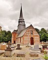
Parish Church of Saint-Nicolas, dedicated to Nicholas of Myra

War memorial ( First World War )
.jpg)
.jpg)
geography
Lintot-les-Bois is a farming village and is 14 kilometers south of Dieppe .
Population development
The population is known from censuses since 1793. The population up to 2005 is published on the website of the École des Hautes Études en Sciences Sociales .
| year | Population |
|---|---|
| 1962 | 143 |
| 1968 | 154 |
| 1975 | 151 |
| 1982 | 174 |
| 1990 | 176 |
| 1999 | 151 |
| 2006 | 180 |
| 2015 | 182 |
Web links
Commons : Lintot-les-Bois - Collection of images, videos and audio files
Individual evidence
- ↑ Lintot-les-Bois. Le nombre d'habitants. In: cassini.ehess.fr. École des Hautes Études en Sciences Sociales , p. 2 , accessed on June 8, 2018 (French).
- ↑ Populations légales 2015. Commune de Lintot-les-Bois (76389). In: insee.fr. Institut national de la statistique et des études économiques, p. 2 , accessed on June 8, 2018 (French).