
Haudricourt
| Haudricourt | ||
|---|---|---|
|
||
| region | Normandy | |
| Department | Seine-Maritime | |
| Arrondissement | Dieppe | |
| Canton | Gournay-en-Bray | |
| Community association | Aumale Blangy-sur-Bresle | |
| Coordinates | 49 ° 44 ′ N , 1 ° 42 ′ E | |
| height | 125-240 m | |
| surface | 29.98 km 2 | |
| Residents | 416 (January 1, 2017) | |
| Population density | 14 inhabitants / km 2 | |
| Post Code | 76390 | |
| INSEE code | 76344 | |
 Town hall (Mairie) of Haudricourt |
||

Haudricourt one is French village with 416 inhabitants (at January 1, 2017) in the department of Seine-Maritime in the region Normandy (before 2016 Haute-Normandie ). It belongs to the Arrondissement Dieppe and is part of the canton of Gournay-en-Bray (until 2015 Aumale ). The inhabitants are called Haudricourtois .
geography
Haudricourt is about 55 kilometers northeast of Rouen . Haudricourt is surrounded by the neighboring communities of Marques and Morienne in the north, Aumale in the northeast, Quincampoix-Fleuzy in the east and northeast, Saint-Valery in the east, Lannoy-Cuillère in the east and southeast, Criquiers in the south, Conteville in the southwest, Ronchois in the west and Southwest and Illois in the west.
The A29 autoroute runs through the municipality .
Population development
| year | 1962 | 1968 | 1975 | 1982 | 1990 | 1999 | 2006 | 2013 |
| Residents | 508 | 423 | 491 | 456 | 443 | 443 | 457 | 464 |
| Source: Cassini and INSEE | ||||||||
Attractions
- Saint-Jean-et-Saint-Martin church in Haudricourt
- Notre-Dame church in Villers
- Beaufresne Church
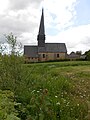
Saint-Jean-et-Saint-Martin church

Notre-Dame church

Beaufresne Church


