
Le Bourg-Dun
| Le Bourg-Dun | ||
|---|---|---|
.svg)
|
|
|
| region | Normandy | |
| Department | Seine-Maritime | |
| Arrondissement | Dieppe | |
| Canton | Saint-Valery-en-Caux | |
| Community association | Côte d'Albâtre | |
| Coordinates | 49 ° 52 ' N , 0 ° 53' E | |
| height | 7-70 m | |
| surface | 14.74 km 2 | |
| Residents | 431 (January 1, 2017) | |
| Population density | 29 inhabitants / km 2 | |
| Post Code | 76550 | |
| INSEE code | 76133 | |
| Website | http://le-bourg-dun.fr/ | |

Le Bourg-Dun is a French municipality with 431 inhabitants (as of January 1 2017) in the department of Seine-Maritime in the region Normandy . It belongs to the Arrondissement of Dieppe and the canton of Saint-Valery-en-Caux (until 2015: canton of Offranville ).
geography
Le Bourg-Dun is about twelve kilometers west-southwest of Dieppe on the River Dun . Le Bourg-Dun is surrounded by the neighboring communities of Saint-Aubin-sur-Mer in the north, Quiberville in the northeast, Longueil in the east, Avremesnil in the southeast, Saint-Pierre-le-Vieux in the south, and La Chapelle-sur-Dun in the west Southwest and Sotteville-sur-Mer to the west and northwest.
Population development
| year | 1962 | 1968 | 1975 | 1982 | 1990 | 1999 | 2006 | 2013 |
| Residents | 504 | 514 | 458 | 419 | 481 | 440 | 455 | 419 |
| Source: Cassini and INSEE | ||||||||
Attractions
- Notre-Dame church, a historic monument since 1862
- Saint-Julien chapel in Flainville from the 14th century, monument historique since 2005
- 16th century mansion of Flainville
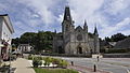
Notre-Dame church

Saint-Julien Chapel


Web links
Commons : Le Bourg-Dun - Collection of images, videos and audio files