Pays de Bray
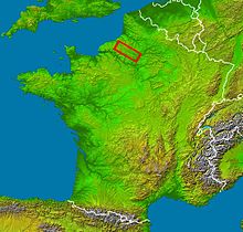
The Pays de Bray is a natural area in France on the border of the Seine-Maritime and Oise departments . It lies between Neufchâtel-en-Bray and Beauvais . The hedge landscape ( bocage ) is part of the large limestone plateau, which also includes the northern part of Picardy , the Pays de Caux , the Pays de Thelle and the Vexin . It is characterized by its clay mineral soils . Dairy farming dominates the landscape.
Classification
The part in the Seine-Maritime department is the Bray normand and the part in the Oise department is the Bray Picard .
Hydrography
The Epte , the Andelle (both right tributaries of the Seine ), the Béthune , the Varenne and the Eaulne (source rivers of the Arques ) and the Avelon , which flows into the Thérain , a tributary of the Oise, arise in the Pays de Bray , pours.
Places in the region
Important places are Neufchâtel-en-Bray , Forges-les-Eaux , Gournay-en-Bray and Saint-Saëns in the part in Haute-Normandie and Auneuil in the Picardy part.
Protected designations of origin
There are three Protected Designations of Origin (AOC) in the landscape: Neufchâtel (cheese) , Calvados and Pommeau de Normandie .
Ceramic industry and craft
The pottery trade has a long tradition in several communities in Bray Picard , such as Savignies , Lachapelle-aux-Pots , Saint-Germain-la-Poterie and Saint-Paul . Already at the end of the Middle Ages, pottery was exported to England and across the Rhine. The brick making industry also flourished in the 19th century. Tile production developed in the second half of the 19th century; some of the companies are still working.
Coordinates: 49 ° 50 ′ 0 ″ N , 1 ° 25 ′ 0 ″ E
