Région naturelle in France
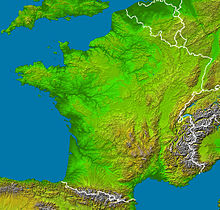
The Régions naturelles in France can not only be delimited according to geomorphological , geological and hydrological characteristics, but also often have a historically homogeneous settlement and their own cultural identity.
France's western half consists mainly of plains and hills . These include the historical landscapes of Aquitaine , Vendée , Brittany , Normandy , Île-de-France , Picardy and French Flanders from southwest to northeast , followed by Belgian Flanders .
In the Champagne , the lowlands merge into the northern French layered plain , which extends from the Ardennes in the border area with Belgium to the Vosges . Geomorphologically, the Palatinate Forest in Germany is part of this natural area .
The Central Massif connects to the south-west and extends from southern Burgundy over the Auvergne to the Cevennes .
To the east of the Massif Central, separated from it by the Rhône and Saône valleys, lie the Alps . Its French part stretches from the Jura (which is partly part of the northern French layered area) to the Maritime Alps .
The Côte d'Azur and Languedoc form a narrow strip of lower land between the Mediterranean , the Alps, the Massif Central and the Pyrenees .

