Bresle (river)
| Bresle | ||
|
Catchment area of the Bresle |
||
| Data | ||
| Water code | FR : G01-0400 | |
| location | France , Normandy and Hauts-de-France regions | |
| River system | Bresle | |
| source | in the municipality of Criquiers 49 ° 41 ′ 25 ″ N , 1 ° 45 ′ 1 ″ E |
|
| Source height | approx. 176 m | |
| muzzle | at Le Tréport in the English Channel Coordinates: 50 ° 3 ′ 53 ″ N , 1 ° 22 ′ 10 ″ E 50 ° 3 ′ 53 ″ N , 1 ° 22 ′ 10 ″ E |
|
| Mouth height | approx. 0 m | |
| Height difference | approx. 176 m | |
| Bottom slope | approx. 2.6 ‰ | |
| length | 68 km | |
| Catchment area | 761 km² | |
| Right tributaries | Liger , Vimeuse | |
| Small towns | Eu , Le Tréport | |
| Ports | Le Tréport | |
| Navigable | in the estuary, earlier to the city of Eu | |
|
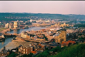
The river between Le Tréport and Mers-les-Bains |
||
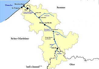
The Bresle is a river in France that marks the border between the regions of Normandy and Hauts-de-France for almost its entire length . It rises in the municipality of Criquiers , drains generally in a north-westerly direction through a river valley with many lakes and flows into the English Channel after 68 kilometers in Le Tréport . On its way, the Bresle touches the Seine-Maritime , Oise and Somme departments .
Places on the river
- Lannoy-Cuillère
- Aumale
- Senarpont
- Bouttencourt
- Blangy-sur-Bresle
- Gamaches
- Beauchamps
- Incheville
- Ponts-et-Marais
- Eu
- Mers-les-Bains
- Le Tréport
Web links
Commons : Bresle - collection of images, videos and audio files

