Senarpont
| Senarpont | ||
|---|---|---|

|
|
|
| region | Hauts-de-France | |
| Department | Somme | |
| Arrondissement | Amiens | |
| Canton | Poix-de-Picardy | |
| Community association | Somme Sud-Ouest | |
| Coordinates | 49 ° 53 ' N , 1 ° 43' E | |
| height | 61-177 m | |
| surface | 7 km 2 | |
| Residents | 647 (January 1, 2017) | |
| Population density | 92 inhabitants / km 2 | |
| Post Code | 80140 | |
| INSEE code | 80732 | |
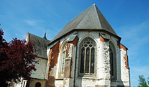
 Saint-Denis church |
||
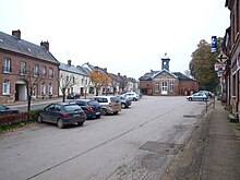
Senarpont ( Picard Ésnèrpont ) is a northern French municipality with 647 inhabitants (at January 1, 2017) in the department of Somme in the region of Hauts-de-France . The municipality is located in the Arrondissement of Amiens (since 2009) and is part of the Communauté de communes Somme Sud-Ouest and the canton of Poix-de-Picardie .
geography
The municipality is located at the confluence of the Liger River into the Bresle, around eight km southwest of Oisemont at the intersection of the D1015, an old Roman road, D25 to Guimerville ( Hodeng-au-Bosc ) in the Seine-Maritime department on the opposite bank of the Bresle and D211 to Hornoy-le-Bourg, 15 km away . The railway line from Aumale to Le Tréport runs on the other side of the Bresle outside the municipality.
history
1463 awarded King Ludwig XI. the right to hold two annual markets.
Residents
| 1962 | 1968 | 1975 | 1982 | 1990 | 1999 | 2006 | 2011 |
|---|---|---|---|---|---|---|---|
| 515 | 635 | 727 | 769 | 800 | 770 | 718 | 677 |
Attractions
- Saint-Denis church
- War memorial
Personalities
- Karl Heinrich von Nassau-Siegen, Prince de Nassau (1743–1808), circumnavigator and Russian admiral.

