
Bourdon (Somme)
| Bourdon | ||
|---|---|---|
|
||
| region | Hauts-de-France | |
| Department | Somme | |
| Arrondissement | Amiens | |
| Canton | Ailly-sur-Somme | |
| Community association | Nièvre et Somme | |
| Coordinates | 49 ° 59 ′ N , 2 ° 5 ′ E | |
| height | 8-78 m | |
| surface | 6.97 km 2 | |
| Residents | 385 (January 1, 2017) | |
| Population density | 55 inhabitants / km 2 | |
| Post Code | 80310 | |
| INSEE code | 80123 | |
 Entrance from the direction of Hangest-sur-Somme |
||

Bourdon ( Picard : Bordon ) is a northern French municipality with 385 inhabitants (at January 1, 2017) in the department of Somme in the region of Hauts-de-France . The municipality is located in the arrondissement of Amiens , is part of the Communauté de communes Nièvre et Somme and belongs to the canton of Ailly-sur-Somme .
geography
Bourdon is about eight kilometers northwest of Picquigny on the right (northern) bank of the Somme , whose valley is interspersed with ponds, and is connected by a bridge to Hangest-sur-Somme on the other bank . The eastern part of the municipality is traversed by the former Route nationale 1 (previously Route nationale 35 ).
Residents
| 1962 | 1968 | 1975 | 1982 | 1990 | 1999 | 2006 | 2011 |
|---|---|---|---|---|---|---|---|
| 274 | 259 | 274 | 294 | 337 | 373 | 380 | 386 |
Attractions
- Saint-Martin church, whose tower with pointed helmet was registered as a Monument historique in 1926 ( Base Mérimée PA00116103)
- German war cemetery designed by Paul Schmitthenner with 22,216 burials from the Second World War
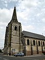
Saint Martin Church

Round tower of the war cemetery


Web links
Commons : Bourdon - collection of images, videos and audio files