
Forceville-en-Vimeu
| Forceville-en-Vimeu | ||
|---|---|---|

|
|
|
| region | Hauts-de-France | |
| Department | Somme | |
| Arrondissement | Amiens | |
| Canton | Poix-de-Picardy | |
| Community association | Somme Sud-Ouest | |
| Coordinates | 49 ° 58 ′ N , 1 ° 48 ′ E | |
| height | 72-119 m | |
| surface | 2.97 km 2 | |
| Residents | 238 (January 1, 2017) | |
| Population density | 80 inhabitants / km 2 | |
| Post Code | 80140 | |
| INSEE code | 80330 | |
.JPG) Saint-Gilles Church |
||

Forceville-en-Vimeu ( Picard : Feurville-in-Vimeu ) is a northern French municipality with 238 inhabitants (at January 1, 2017) in the department of Somme in the region of Hauts-de-France . The municipality is located in the Arrondissement of Amiens (since 2009) and is part of the Communauté de communes Somme Sud-Ouest and the canton of Poix-de-Picardie .
geography
The community is located immediately east-northeast of the Oisemont, which is around three kilometers to the west, on the Vimeu plateau . The abandoned railway line from Longpré-les-Corps-Saints to Gamaches ran through the municipality .
economy
There is a yarn factory in the west of the municipality.
Residents
| 1962 | 1968 | 1975 | 1982 | 1990 | 1999 | 2006 | 2011 |
|---|---|---|---|---|---|---|---|
| 358 | 310 | 306 | 279 | 261 | 262 | 268 | 260 |
Attractions
- Saint-Gilles Church
- 17th century castle
- War memorial
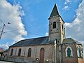
Saint-Gilles church from the north

War memorial
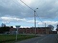
Factory building
.JPG)
.JPG)

Web links
Commons : Forceville-en-Vimeu - collection of images, videos and audio files