Tailly (Somme)
| Tailly | ||
|---|---|---|
|
|
||
| region | Hauts-de-France | |
| Department | Somme | |
| Arrondissement | Amiens | |
| Canton | Ailly-sur-Somme | |
| Community association | Somme Sud-Ouest | |
| Coordinates | 49 ° 56 ' N , 1 ° 57' E | |
| height | 32-87 m | |
| surface | 4.05 km 2 | |
| Residents | 59 (January 1, 2017) | |
| Population density | 15 inhabitants / km 2 | |
| Post Code | 80270 | |
| INSEE code | 80744 | |
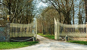
 Entrance to the castle |
||
Tailly is a northern French municipality with 59 inhabitants (at January 1, 2017) in the department of Somme in the region of Hauts-de-France . The municipality is located in the arrondissement of Amiens , is part of the Communauté de communes Somme Sud-Ouest and belongs to the canton of Ailly-sur-Somme .
geography
Tailly is on the former Route nationale 1 just north of Warlus and around 4.5 kilometers south of Airaines . The castle is around 500 m west of the village. The hamlet of L'Arbre-à-Mouches belongs to Tailly.
history
Traces of Gallic settlement have been found in Tailly, whose name is supposed to be derived from the Latin Tilia (linden tree). Tailly's rule depended on Aumale .
In the 20th century, the castle was owned by Major General Jacques-Philippe Leclerc de Hauteclocque (1902–1947), who was born in neighboring Belloy-Saint-Léonard and who liked to hunt here.
Residents
| 1962 | 1968 | 1975 | 1982 | 1990 | 1999 | 2006 | 2011 |
|---|---|---|---|---|---|---|---|
| 62 | 73 | 60 | 51 | 72 | 64 | 63 | 60 |
administration
Mayor ( maire ) has been Sylviane Calippe since 2008.
Attractions
- Saint-Martin church from the 18th century
- Tailly-l'Arbre-aux-Mouches castle, built from 1730, registered as a monument historique in 1995 ( Base Mérimée PA00135580) with a park and exhibition in memory of Leclerc and the liberation of France
