Neuville-Coppegueule
| Neuville-Coppegueule | ||
|---|---|---|
|
|
||
| region | Hauts-de-France | |
| Department | Somme | |
| Arrondissement | Amiens | |
| Canton | Poix-de-Picardy | |
| Community association | Somme Sud-Ouest | |
| Coordinates | 49 ° 51 ′ N , 1 ° 45 ′ E | |
| height | 75-204 m | |
| surface | 8.66 km 2 | |
| Residents | 521 (January 1, 2017) | |
| Population density | 60 inhabitants / km 2 | |
| Post Code | 80430 | |
| INSEE code | 80592 | |
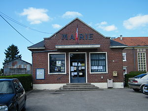
 Town hall (mairie) |
||
Neuville-Coppegueule ( Picard : Neuville-Cobieule ) is a northern French municipality with 521 inhabitants (at January 1, 2017) in the department of Somme in the region of Hauts-de-France . The municipality is located in the Arrondissement of Amiens (since 2009) and is part of the Communauté de communes Somme Sud-Ouest and the canton of Poix-de-Picardie .
geography
The municipality is located around twelve kilometers west of Hornoy-le-Bourg and ten kilometers north of Aumale and borders the Bresle River to the west . The railway line from Aumale to Le Tréport runs on the other side of the Bresle outside the municipality. In the Bresle valley, the commune includes the farms La Teinturerie, Sottoleux, La Basse Neuville, La Rosière and the mill Le Moulin à Foulon. The hamlet of Les Maisons-Neuves, which has grown together with the core municipality, also belongs to the municipality. The Forêt d'Arguel occupies the north of the municipality.
economy
The community is one of the centers of at the nearby valley of the river Liger operated Flechtstuhlherstellung .
Residents
| 1962 | 1968 | 1975 | 1982 | 1990 | 1999 | 2006 | 2011 |
|---|---|---|---|---|---|---|---|
| 672 | 647 | 605 | 614 | 586 | 535 | 593 | 577 |
Sons and daughters
- Jean-Paul Gusching (* 1955), Catholic clergyman, Bishop of Verdun

