Nampty
| Nampty | ||
|---|---|---|
|
|
||
| region | Hauts-de-France | |
| Department | Somme | |
| Arrondissement | Amiens | |
| Canton | Ailly-sur-Noye | |
| Community association | Somme Sud-Ouest | |
| Coordinates | 49 ° 48 ' N , 2 ° 12' E | |
| height | 40-145 m | |
| surface | 5.21 km 2 | |
| Residents | 289 (January 1, 2017) | |
| Population density | 55 inhabitants / km 2 | |
| Post Code | 80160 | |
| INSEE code | 80583 | |
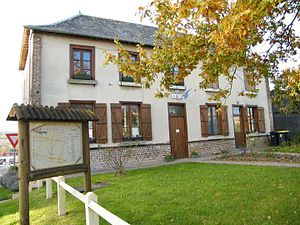
 Mairie Nampty |
||
Nampty ( Picard : Nanty ) is a northern French municipality with 289 inhabitants (at January 1, 2017) in the department of Somme in the region of Hauts-de-France . The municipality is located in the arrondissement of Amiens and belongs to the canton of Ailly-sur-Noye .
geography
The community is located around eleven kilometers southwest of Amiens, almost entirely on the right (eastern) bank of the Selle , over which two bridges lead here. It extends to the east over the plateau between the Selle and Noye rivers almost to the A16 autoroute .
history
In 1470 Nampty was burned down by Burgundian troops.
| 1962 | 1968 | 1975 | 1982 | 1990 | 1999 | 2006 | 2010 |
|---|---|---|---|---|---|---|---|
| 113 | 131 | 135 | 198 | 196 | 205 | 235 | 244 |
administration
Mayor ( maire ) has been Philippe Cocq since 2008.
Attractions
- Notre-Dame des Vertus pilgrimage chapel
Web links
Commons : Nampty - collection of pictures, videos and audio files

