Dreuil-lès-Amiens
| Dreuil-lès-Amiens | ||
|---|---|---|
|
|
||
| region | Hauts-de-France | |
| Department | Somme | |
| Arrondissement | Amiens | |
| Canton | Ailly-sur-Somme | |
| Community association | Amiens metropolis | |
| Coordinates | 49 ° 55 ' N , 2 ° 14' E | |
| height | 12-87 m | |
| surface | 3.18 km 2 | |
| Residents | 1,653 (January 1, 2017) | |
| Population density | 520 inhabitants / km 2 | |
| Post Code | 80470 | |
| INSEE code | 80256 | |
| Website | http://www.ville-dreuil-les-amiens.fr/article.do&id=961 | |
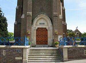
 Access to the church |
||
Dreuil-lès-Amiens ( Picard : Dréeuil-lès-Anmien ) is a northern French municipality with 1653 inhabitants (at January 1, 2017) in the department of Somme in the region of Hauts-de-France . The municipality is located in the arrondissement of Amiens , is part of the Communauté d'agglomération Amiens Métropole and belongs to the canton of Ailly-sur-Somme .
geography
Dreuil is located around 5.5 km west of Amiens and immediately adjacent to its Étouvie district on the left (southern) bank of the Somme , whose valley is interspersed with ponds, opposite Argœuves , on the D1235 (former Route nationale 35 ). The railway line to Abbeville also runs through the municipality.
history
Traces of a Gallo-Roman villa have been found in Dreuil. The place that paid homage to neighboring Ailly-sur-Somme to the west was first mentioned in 1120. In the French Revolution in 1789, the castle and a salt store were destroyed. The church, dedicated to Saint Riquier, was built in 1850. Farm workers' houses were built around them.
Residents
| 1962 | 1968 | 1975 | 1982 | 1990 | 1999 | 2006 | 2011 |
|---|---|---|---|---|---|---|---|
| 569 | 602 | 1,077 | 1,408 | 1,613 | 1,476 | 1,290 | 1,278 |
administration
Mayor ( maire ) has been Michel Thieffaine since 2001.
Attractions
- Saint-Riquier Church [1]
- War memorials
