Blangy-sous-Poix
| Blangy-sous-Poix | ||
|---|---|---|
|
|
||
| region | Hauts-de-France | |
| Department | Somme | |
| Arrondissement | Amiens | |
| Canton | Poix-de-Picardy | |
| Community association | Somme Sud-Ouest | |
| Coordinates | 49 ° 46 ′ N , 2 ° 0 ′ E | |
| height | 85-189 m | |
| surface | 8.01 km 2 | |
| Residents | 181 (January 1, 2017) | |
| Population density | 23 inhabitants / km 2 | |
| Post Code | 80290 | |
| INSEE code | 80106 | |
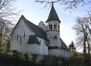
 Saint-Médard church |
||
Blangy-sous-Poix ( Picard : Blangy-DSOU-Poé ) is a northern French municipality with 181 inhabitants (at January 1, 2017) in the department of Somme in the region of Hauts-de-France . The municipality is located in the Arrondissement of Amiens , is part of the Communauté de communes Somme Sud-Ouest and belongs to the canton of Poix-de-Picardie .
geography
Blangy is located on the former Route nationale 320 in the valley of the River Poix (sometimes also called the northern arm of the Évoissons ) between Poix-de-Picardie , which it directly borders, and Famechon . The railway line from Amiens to Rouen runs through the municipality .
Residents
| 1962 | 1968 | 1975 | 1982 | 1990 | 1999 | 2006 | 2011 |
|---|---|---|---|---|---|---|---|
| 102 | 94 | 82 | 89 | 97 | 105 | 127 | 123 |
administration
Mayor ( maire ) has been Alain Lesur since 2001.
Attractions
- Saint-Médard church on the eastern edge of the parish.
Web links
Commons : Blangy-sous-Poix - collection of images, videos and audio files
