Bertangles
| Bertangles | ||
|---|---|---|

|
|
|
| region | Hauts-de-France | |
| Department | Somme | |
| Arrondissement | Amiens | |
| Canton | Amiens-2 | |
| Community association | Amiens metropolis | |
| Coordinates | 49 ° 58 ′ N , 2 ° 18 ′ E | |
| height | 51-131 m | |
| surface | 8.57 km 2 | |
| Residents | 627 (January 1, 2017) | |
| Population density | 73 inhabitants / km 2 | |
| Post Code | 80260 | |
| INSEE code | 80092 | |
| Website | http://www.ville-bertangles.fr | |
 lock |
||
Bertangles ( Picard : Bèrtangue) is a northern commune with 627 inhabitants (at January 1, 2017) in the Somme department in the region of Hauts-de-France . The municipality is located in the canton of Amiens-2 and is part of the Communauté d'agglomération Amiens Métropole .
geography
Bertangles is located on the D97 department road about ten kilometers north of Amiens and extends from Route nationale 25 in the east to the D933 department road in the west. The no longer served railway line from Amiens to Doullens also runs through the municipality. The castle is located on the southern edge of the Bois de Bertangles.
history
Bertangles, first mentioned in 1103, was under the rule of the Lords of Bertangles and later the de Glisy family until they came to Clermont-Tonnerre in 1611.
Residents
| 1962 | 1968 | 1975 | 1982 | 1990 | 1999 | 2006 | 2010 |
|---|---|---|---|---|---|---|---|
| 284 | 287 | 387 | 646 | 700 | 654 | 610 | 585 |
administration
Mayor (maire) has been Joseph Debart since 2001.
Attractions
- Saint-Vincent church, registered as a monument historique in 2001 (Base Mérimée PA80000028)
- Built between 1730 and 1734 under the Counts of Clermont-Tonnerre , fire damaged in 1930 with a wrought iron grille by Jean Veyren and a dovecote ( classified as Monument historique in 1982 and 2006 , Base Mérimée PA00116222)
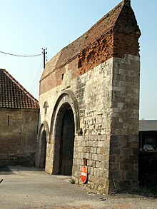
- Gate to the medieval castle

