
Le Translay
| Le Translay | ||
|---|---|---|
|
||
| region | Hauts-de-France | |
| Department | Somme | |
| Arrondissement | Amiens | |
| Canton | Poix-de-Picardy | |
| Community association | Somme Sud-Ouest | |
| Coordinates | 49 ° 58 ′ N , 1 ° 41 ′ E | |
| height | 109-139 m | |
| surface | 5.61 km 2 | |
| Residents | 248 (January 1, 2017) | |
| Population density | 44 inhabitants / km 2 | |
| Post Code | 80140 | |
| INSEE code | 80767 | |
|
Saint-Jean-Baptiste church |
||

Le Translay ( Picard : L'Tranlay ) is a northern French municipality with 248 inhabitants (at January 1, 2017) in the department of Somme in the region of Hauts-de-France . The municipality is located in the Arrondissement of Amiens and is part of the Communauté de communes Somme Sud-Ouest and the canton of Poix-de-Picardie .
geography
The municipality traversed by the A28 autoroute is located on the plateau above the left bank of the Bresle . The district of Busménard is west of the motorway, the other built-up area is east of it.
Residents
| 1962 | 1968 | 1975 | 1982 | 1990 | 1999 | 2006 | 2011 |
|---|---|---|---|---|---|---|---|
| 202 | 201 | 202 | 198 | 200 | 182 | 197 | 235 |
administration
Mayor ( maire ) has been Jean de Beaufort since 2014.
Attractions
- Saint-Jean-Baptiste church
- Saint-Martin chapel in Busménard
- Castle in Busménard from 1755
- Moth on a rectangular plan
- War memorial
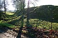
moth
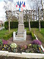
War memorial
Individual evidence
- ↑ http://clochers.org/Fichiers_HTML/Accueil/Accueil_clochers/80/accueil_80767.htm
- ↑ Château de Busménard in the Base Mérimée of the French Ministry of Culture (French)
Web links
Commons : Le Translay - collection of images, videos and audio files