
Fresnes-Tilloloy
| Fresnes-Tilloloy | ||
|---|---|---|
|
||
| region | Hauts-de-France | |
| Department | Somme | |
| Arrondissement | Amiens | |
| Canton | Poix-de-Picardy | |
| Community association | Somme Sud-Ouest | |
| Coordinates | 49 ° 59 ′ N , 1 ° 46 ′ E | |
| height | 89-116 m | |
| surface | 3.52 km 2 | |
| Residents | 203 (January 1, 2017) | |
| Population density | 58 inhabitants / km 2 | |
| Post Code | 80140 | |
| INSEE code | 80354 | |
 Town Hall (Mairie) |
||

Fresnes-Tilloloy ( Picard : Frène-Tilloloé ) is a northern French municipality with 203 inhabitants (at January 1, 2017) in the department of Somme in the region of Hauts-de-France . The municipality is located in the Arrondissement of Amiens (since 2009) and is part of the Communauté de communes Somme Sud-Ouest and the canton of Poix-de-Picardie .
geography

The community, a street village, is located directly on Oisemont, around three kilometers south, on the Vimeu plateau . In the north of the municipality there is a wind farm across the neighboring municipalities of Saint-Maxent and Doudelainville . A section of the Chaussée Brunehaut system runs in the southwest of the municipality .
history
Finds suggest Gallo-Roman settlement. The Chaussée Brunehaut runs on a Roman road. In 1459 Fresnes and Tilloloy each had their own vicar and belonged to the parish of Oisemont. In 1660 a castle in Fresnes is attested. The plague claimed many victims in the 18th century. During the French Revolution , Fresnes and Tilloloy formed a single community. The school was opened in 1797. In 1871 the place was occupied by Prussian troops. In January 1944 the place was bombed; the attack was aimed at nearby missile launchers.
Residents
| 1962 | 1968 | 1975 | 1982 | 1990 | 1999 | 2006 | 2011 |
|---|---|---|---|---|---|---|---|
| 147 | 134 | 130 | 134 | 130 | 137 | 135 | 178 |
Attractions
- 19th century castle
- Saint-Ouen church built in 1887; the previous church had been demolished a few years earlier
- War memorial
- Hall crosses

Saint-Ouen church
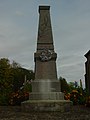
War memorial

