Sainte-Segrée
| Sainte-Segrée | ||
|---|---|---|
|
|
||
| region | Hauts-de-France | |
| Department | Somme | |
| Arrondissement | Amiens | |
| Canton | Poix-de-Picardy | |
| Community association | Somme Sud-Ouest | |
| Coordinates | 49 ° 45 ' N , 1 ° 55' E | |
| height | 132-189 m | |
| surface | 2.27 km 2 | |
| Residents | 57 (January 1, 2017) | |
| Population density | 25 inhabitants / km 2 | |
| Post Code | 80290 | |
| INSEE code | 80719 | |
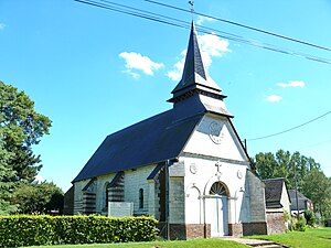
 Church of the Assumption of Mary |
||
Sainte-Segrée ( Picard : Sainte-Grée ) is a northern French municipality with 57 inhabitants (at January 1, 2017) in the department of Somme in the region of Hauts-de-France . The municipality is located in the Arrondissement of Amiens , is part of the Communauté de communes Somme Sud-Ouest and belongs to the canton of Poix-de-Picardie .
geography
The municipality is located on the left bank of the Poix , a small tributary of the Évoissons about one km northwest of Thielloy-la-Ville and about eight km west of Poix-de-Picardie and 12.5 km east of Aumale . Sainte-Segrée has a stop on the railway from Amiens to Rouen .
history
The community was burned down in 1472 by the troops of Charles the Bold .
Residents
| 1962 | 1968 | 1975 | 1982 | 1990 | 1999 | 2006 | 2011 |
|---|---|---|---|---|---|---|---|
| 75 | 92 | 88 | 76 | 50 | 56 | 54 | 60 |
administration
Gérard Desmarest has been mayor ( maire ) since 2001.
Attractions
- Assumption Church from the beginning of the 16th century
- Sainte-Segrée castle from the 18th century with park ( Base Mérimée IA80000672).
Web links
Commons : Sainte-Segrée - Collection of images, videos and audio files
