
Domléger-Longvillers
| Domléger-Longvillers | ||
|---|---|---|
|
||
| region | Hauts-de-France | |
| Department | Somme | |
| Arrondissement | Amiens | |
| Canton | Doullens | |
| Community association | Territoire North Picardy | |
| Coordinates | 50 ° 10 ′ N , 2 ° 5 ′ E | |
| height | 100-142 m | |
| surface | 8.91 km 2 | |
| Residents | 302 (January 1, 2017) | |
| Population density | 34 inhabitants / km 2 | |
| Post Code | 80370 | |
| INSEE code | 80245 | |
.JPG) Mairie and Meeting House |
||

Domléger-Longvillers ( Picard : Donnegé-Neuvilé ) is a northern French municipality with 302 inhabitants (at January 1, 2017) in the department of Somme in the region of Hauts-de-France . The municipality is located in the Arrondissement of Amiens and is part of the Communauté de communes du Territoire Nord Picardie and the canton of Doullens .
geography
The municipality, with its two parts Domléger in the north and Longvillers in the south, is adjacent to Agenville , with which it shares school and Mairie, around eight kilometers west of Bernaville and 10.5 kilometers east of Saint-Riquier on the Ponthieu plateau .
history
In the course of the incursions of Spanish troops in 1647, basements ("muches") were dug to protect the population. Domléger and Longvillers merged on October 1, 1972 to form a single municipality.
Residents
| 1962 | 1968 | 1975 | 1982 | 1990 | 1999 | 2006 | 2011 |
|---|---|---|---|---|---|---|---|
| 175 | 183 | 312 | 255 | 257 | 267 | 265 | 282 |
Attractions
- Saint-Léger church in Domléger
- Saint-Lô Church in Longvillers; her tower collapsed in 2008
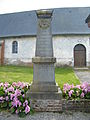
- War memorials in both parts of the community

Saint-Léger church in Domléger

towerless church of Saint-Lô in Longvillers

War memorial in Domléger
War memorial in Longvillers
.JPG)
.JPG)
.JPG)
.JPG)