
Grattepanche
| Grattepanche | ||
|---|---|---|
|
||
| region | Hauts-de-France | |
| Department | Somme | |
| Arrondissement | Amiens | |
| Canton | Ailly-sur-Noye | |
| Community association | Amiens metropolis | |
| Coordinates | 49 ° 47 ' N , 2 ° 18' E | |
| height | 69-125 m | |
| surface | 6.43 km 2 | |
| Residents | 318 (January 1, 2017) | |
| Population density | 49 inhabitants / km 2 | |
| Post Code | 80680 | |
| INSEE code | 80387 | |
| Website | http://www.grattepanche-mairie.fr/index1024.htm | |
 Saint-Cyr et Sainte-Julitte church |
||

Grattepanche is a northern French municipality with 318 inhabitants (at January 1, 2017) in the department of Somme in the region of Hauts-de-France . The municipality is located in the arrondissement of Amiens , is part of the Communauté d'agglomération Amiens Métropole and belongs to the canton of Ailly-sur-Noye .
geography
The community, traversed by two dry valleys, is located on the plateau between the Noye and Selle rivers, around 15 kilometers south of the departmental capital, Amiens .
Toponymy and History
The name of the community is derived from the Latin name Gratiani pagus.
| 1962 | 1968 | 1975 | 1982 | 1990 | 1999 | 2006 | 2010 |
|---|---|---|---|---|---|---|---|
| 153 | 120 | 148 | 179 | 243 | 269 | 288 | 293 |
administration
Mayor ( maire ) has been Maurice Navarre since 2001.
Attractions
- Parish Church of Saint-Cyr et Sainte-Julitte
- War memorial
- Calvary
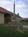
Calvary
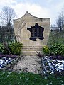
War memorial


Web links
Commons : Grattepanche - collection of images, videos and audio files