Arguel (Somme)
| Arguel | ||
|---|---|---|

|
|
|
| region | Hauts-de-France | |
| Department | Somme | |
| Arrondissement | Amiens | |
| Canton | Poix-de-Picardy | |
| Community association | Somme Sud-Ouest | |
| Coordinates | 49 ° 52 ′ N , 1 ° 48 ′ E | |
| height | 109-177 m | |
| surface | 2.54 km 2 | |
| Residents | 29 (January 1, 2017) | |
| Population density | 11 inhabitants / km 2 | |
| Post Code | 80140 | |
| INSEE code | 80026 | |
| Website | http://arguel.org/ | |
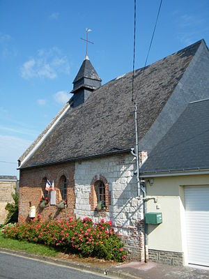
 Saint-Jean-Baptiste church |
||
Arguel ( Picard Ardjué ) is a French municipality with 29 inhabitants (at January 1, 2017) in the department of Somme in the region of Hauts-de-France . It belongs to the Arrondissement of Amiens and the Poix-de-Picardie .
geography
Arguel is located north of Le Quesne on the sharp edge of the slope that accompanies the river Liger in the north and extends over the plateau of the Vimeu landscape .
history
The municipality takes the place of an old Roman camp, in the place of which Renouard d'Arguel built a castle at the turn of the 11th and 12th centuries, which was captured by English troops in the Hundred Years War in 1347. The French reconquest took place in 1402.
Residents
| 1962 | 1968 | 1975 | 1982 | 1990 | 1999 | 2006 | 2012 |
|---|---|---|---|---|---|---|---|
| 78 | 54 | 30th | 35 | 31 | 35 | 32 | 29 |
Attractions
- Saint-Jean-Baptiste church
- Castle hill (motte féodale) with a calvary from 1861 and a large cross
Web links
Commons : Arguel - collection of images, videos and audio files
- Official website (French)
