Hénencourt
| Hénencourt | ||
|---|---|---|

|
|
|
| region | Hauts-de-France | |
| Department | Somme | |
| Arrondissement | Amiens | |
| Canton | Corbie | |
| Community association | Val de Somme | |
| Coordinates | 50 ° 0 ′ N , 2 ° 34 ′ E | |
| height | 83-121 m | |
| surface | 3.26 km 2 | |
| Residents | 195 (January 1, 2017) | |
| Population density | 60 inhabitants / km 2 | |
| Post Code | 80300 | |
| INSEE code | 80429 | |
| Website | http://www.valdesomme.com/index.php?mod=communes&id=13 | |
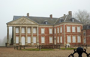
 The lock |
||
Hénencourt ( Picard : Hinincourt) is a northern French municipality with 195 inhabitants (at January 1, 2017) in the department of Somme in the region of Hauts-de-France . The municipality is located in the canton of Corbie and is part of the Communauté de communes du Val de Somme .
geography
The community is about 6.5 km west of Albert at the intersection of the D91 and D119 département roads.
history
A church was built in Hénencourt in 1404.
Residents
| 1962 | 1968 | 1975 | 1982 | 1990 | 1999 | 2006 | 2010 |
|---|---|---|---|---|---|---|---|
| 170 | 174 | 176 | 165 | 205 | 183 | 173 | 192 |
administration
Mayor (maire) has been Michel Vandepitte since 2008.
Attractions
- The castle, rebuilt after its destruction in 1636, with a facade with six Ionic columns from the 18th century, a large park and a pigeon house. The castle has been classified as a Monument historique since 1984 ( Base Mérimée PA00116178).
- The Saint-Maclou church from the 19th century with a classical main altar.
- Three log houses in the municipality.
Web links
Commons : Hénencourt - collection of images, videos and audio files

