Camon (Somme)
| Camon | ||
|---|---|---|
|
|
||
| region | Hauts-de-France | |
| Department | Somme | |
| Arrondissement | Amiens | |
| Canton | Amiens-3 | |
| Community association | Amiens metropolis | |
| Coordinates | 49 ° 53 ' N , 2 ° 21' E | |
| height | 22-84 m | |
| surface | 12.90 km 2 | |
| Residents | 4,432 (January 1, 2017) | |
| Population density | 344 inhabitants / km 2 | |
| Post Code | 80450 | |
| INSEE code | 80164 | |
| Website | http://www.camon.fr/ | |
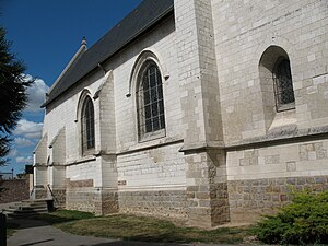
 The Church of Camon |
||
Camon ( Picard : CANMON) is a northern French municipality with 4432 inhabitants (at January 1, 2017) in the department of Somme in the region of Hauts-de-France . The municipality is located in the arrondissement of Amiens , is part of the Communauté d'agglomération Amiens Métropole and belongs to the canton of Amiens-3 .
geography
Camon is a suburb of Amiens , from whose center it is about four kilometers to the east. The municipality is north of the Somme opposite the mouth of the Avre ; The municipality is crossed by the Route nationale 25 , which forms part of the Amiens ring road. The district of Le Petit Camon is located in the north of the municipality on the D929 département road (former Route nationale 29 ) to Albert . The Hortillonages of Amiens are partly in the municipality.
history
Camon was under the cathedral chapter of Amiens in the Middle Ages . Spanish troops burned the place down in 1636.
In the Franco-German War 1870-71 were blown up two bridges.
Residents
| 1962 | 1968 | 1975 | 1982 | 1990 | 1999 | 2006 | 2010 |
|---|---|---|---|---|---|---|---|
| 2.110 | 3,008 | 4,350 | 4.214 | 3,920 | 4,366 | 4,547 | 4,590 |
administration
Mayor ( maire ) has been Jean-Claude Renaux ( Parti communiste français ) since 2001 .
Attractions
- The 16th century church of Saint-Vaast, with modern glazing by Joseph Archepel .
