Croixrault
| Croixrault | ||
|---|---|---|
|
|
||
| region | Hauts-de-France | |
| Department | Somme | |
| Arrondissement | Amiens | |
| Canton | Poix-de-Picardy | |
| Community association | Somme Sud-Ouest | |
| Coordinates | 49 ° 48 ′ N , 2 ° 0 ′ E | |
| height | 111-187 m | |
| surface | 8.96 km 2 | |
| Residents | 434 (January 1, 2017) | |
| Population density | 48 inhabitants / km 2 | |
| Post Code | 80290 | |
| INSEE code | 80227 | |
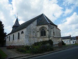
 Saint-Jean-Baptiste church |
||
Croixrault ( Picard : Cloreu ) is a northern French municipality with 434 inhabitants (at January 1, 2017) in the department of Somme in the region of Hauts-de-France . The municipality is located in the Arrondissement of Amiens , is part of the Communauté de communes Somme Sud-Ouest and belongs to the canton of Poix-de-Picardie .
geography
The municipality is located around 29 kilometers southwest of Amiens and two kilometers north of Poix-de-Picardie . It extends in the north to the A29 autoroute , which has a junction here. In Croixrault there is a protected beech tree (La canne du bois).
Residents
| 1962 | 1968 | 1975 | 1982 | 1990 | 1999 | 2006 | 2011 |
|---|---|---|---|---|---|---|---|
| 324 | 372 | 351 | 365 | 356 | 355 | 407 | 441 |
Personalities
- In 1966, Henri-Marie Guilluy OSB founded a monastery for the disabled in Croixrault, from which further foundations resulted in a separate congregation, the generalate of which is located in Croixrault.
Web links
Commons : Croixrault - collection of images, videos and audio files
