Le Meillard
| Le Meillard | ||
|---|---|---|
|
|
||
| region | Hauts-de-France | |
| Department | Somme | |
| Arrondissement | Amiens | |
| Canton | Doullens | |
| Community association | Territoire North Picardy | |
| Coordinates | 50 ° 10 ′ N , 2 ° 12 ′ E | |
| height | 55-142 m | |
| surface | 6.93 km 2 | |
| Residents | 154 (January 1, 2017) | |
| Population density | 22 inhabitants / km 2 | |
| Post Code | 80370 | |
| INSEE code | 80526 | |
 Mairie Le Meillard |
||
Meillard ( Picard : L 'Meiller ) is a northern French municipality with 154 inhabitants (at January 1, 2017) in the department of Somme in the region of Hauts-de-France . The municipality is located in the Arrondissement of Amiens , is part of the Communauté de communes du Territoire Nord Picardie and belongs to the canton of Doullens .
geography
The municipality lies between Bernaville and the valley of the river Authie about five kilometers north-northeast of Bernaville. The parish includes the farms Le Grand Meillard in the south and L'Escarnoy in the north-west. Remnants of Wehrmacht rocket launchers from the Second World War lie on the municipal border with Frohen-sur-Authie .
history
Traces of Gallo-Roman settlement such as sarcophagi and terracottas have been found in the place.
In 1140 he was first mentioned as Meslerd .
Residents
| 1962 | 1968 | 1975 | 1982 | 1990 | 1999 | 2006 | 2011 |
|---|---|---|---|---|---|---|---|
| 190 | 197 | 163 | 134 | 114 | 131 | 140 | 169 |
Attractions
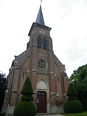
- Saint-Fursy church [1]

