Villeroy (Somme)
| Villeroy | ||
|---|---|---|
|
|
||
| region | Hauts-de-France | |
| Department | Somme | |
| Arrondissement | Amiens | |
| Canton | Poix-de-Picardy | |
| Community association | Somme Sud-Ouest | |
| Coordinates | 49 ° 56 ' N , 1 ° 43' E | |
| height | 119-159 m | |
| surface | 6.02 km 2 | |
| Residents | 190 (January 1, 2017) | |
| Population density | 32 inhabitants / km 2 | |
| Post Code | 80140 | |
| INSEE code | 80796 | |
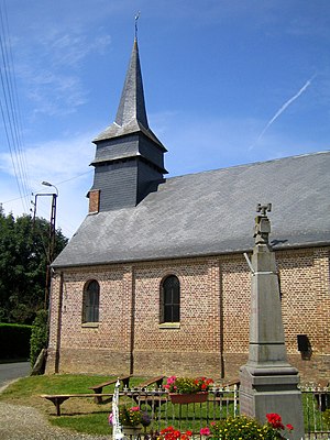
 Saint-Sauveur church and war memorial |
||
Villeroy ( Picard : Viéroé ) is a northern French municipality with 190 inhabitants (at January 1, 2017) in the department of Somme in the region of Hauts-de-France . The municipality is located in the Arrondissement of Amiens (since 2009) and is part of the Communauté de communes Somme Sud-Ouest and the canton of Poix-de-Picardie .
geography
The municipality, which was once served by the railroad, is located in the Vimeu countryside around three kilometers west-southwest of Oisemont , west of the D25 from Oisemont to Senarpont, which borders it in the east .
Toponymy and History
The place that belonged to the Templars , who surrounded it with a wall, is called Villa Regia in 1129. The reign paid homage to Bailleuil and later came to the Lords of Rambures .
Residents
| 1962 | 1968 | 1975 | 1982 | 1990 | 1999 | 2006 | 2011 |
|---|---|---|---|---|---|---|---|
| 247 | 242 | 218 | 205 | 210 | 216 | 218 | 214 |
Attractions
- Saint-Sauveur church, rebuilt in the 19th century, originally from the 16th century
- War memorial
- classical former town hall and school building
Web links
Commons : Villeroy - collection of images, videos and audio files
