
Gretz-Armainvilliers – Sézanne railway line
| Gretz-Armainvilliers-Sézanne | |||||||||||||||||||||||||||||||||||||||||||||||||||||||||||||||||||||||||||||||||||||||||||||||||||||||||||||||||||||||||||||||||||||||||||||||||||||||||||||||||||||||||||||||||||||||||||||||||||||||||||||||||||||||||||||||||||||||||||||||||
|---|---|---|---|---|---|---|---|---|---|---|---|---|---|---|---|---|---|---|---|---|---|---|---|---|---|---|---|---|---|---|---|---|---|---|---|---|---|---|---|---|---|---|---|---|---|---|---|---|---|---|---|---|---|---|---|---|---|---|---|---|---|---|---|---|---|---|---|---|---|---|---|---|---|---|---|---|---|---|---|---|---|---|---|---|---|---|---|---|---|---|---|---|---|---|---|---|---|---|---|---|---|---|---|---|---|---|---|---|---|---|---|---|---|---|---|---|---|---|---|---|---|---|---|---|---|---|---|---|---|---|---|---|---|---|---|---|---|---|---|---|---|---|---|---|---|---|---|---|---|---|---|---|---|---|---|---|---|---|---|---|---|---|---|---|---|---|---|---|---|---|---|---|---|---|---|---|---|---|---|---|---|---|---|---|---|---|---|---|---|---|---|---|---|---|---|---|---|---|---|---|---|---|---|---|---|---|---|---|---|---|---|---|---|---|---|---|---|---|---|---|---|---|---|---|---|---|---|---|---|---|---|---|---|---|---|---|---|---|---|---|---|
 La Ferté-Gaucher station, buffer stop from Sézanne .
| |||||||||||||||||||||||||||||||||||||||||||||||||||||||||||||||||||||||||||||||||||||||||||||||||||||||||||||||||||||||||||||||||||||||||||||||||||||||||||||||||||||||||||||||||||||||||||||||||||||||||||||||||||||||||||||||||||||||||||||||||
| Route number (SNCF) : | 002 000 | ||||||||||||||||||||||||||||||||||||||||||||||||||||||||||||||||||||||||||||||||||||||||||||||||||||||||||||||||||||||||||||||||||||||||||||||||||||||||||||||||||||||||||||||||||||||||||||||||||||||||||||||||||||||||||||||||||||||||||||||||
| Course book route (SNCF) : | 21st | ||||||||||||||||||||||||||||||||||||||||||||||||||||||||||||||||||||||||||||||||||||||||||||||||||||||||||||||||||||||||||||||||||||||||||||||||||||||||||||||||||||||||||||||||||||||||||||||||||||||||||||||||||||||||||||||||||||||||||||||||
| Route length: | 93.4 km | ||||||||||||||||||||||||||||||||||||||||||||||||||||||||||||||||||||||||||||||||||||||||||||||||||||||||||||||||||||||||||||||||||||||||||||||||||||||||||||||||||||||||||||||||||||||||||||||||||||||||||||||||||||||||||||||||||||||||||||||||
| Gauge : | 1435 mm ( standard gauge ) | ||||||||||||||||||||||||||||||||||||||||||||||||||||||||||||||||||||||||||||||||||||||||||||||||||||||||||||||||||||||||||||||||||||||||||||||||||||||||||||||||||||||||||||||||||||||||||||||||||||||||||||||||||||||||||||||||||||||||||||||||
| Power system : |
Gretz-Armainvilliers-Coulommiers : 25 kV 50 Hz ~ |
||||||||||||||||||||||||||||||||||||||||||||||||||||||||||||||||||||||||||||||||||||||||||||||||||||||||||||||||||||||||||||||||||||||||||||||||||||||||||||||||||||||||||||||||||||||||||||||||||||||||||||||||||||||||||||||||||||||||||||||||
| Maximum slope : | 8 ‰ | ||||||||||||||||||||||||||||||||||||||||||||||||||||||||||||||||||||||||||||||||||||||||||||||||||||||||||||||||||||||||||||||||||||||||||||||||||||||||||||||||||||||||||||||||||||||||||||||||||||||||||||||||||||||||||||||||||||||||||||||||
| Dual track : | originally yes, today no | ||||||||||||||||||||||||||||||||||||||||||||||||||||||||||||||||||||||||||||||||||||||||||||||||||||||||||||||||||||||||||||||||||||||||||||||||||||||||||||||||||||||||||||||||||||||||||||||||||||||||||||||||||||||||||||||||||||||||||||||||
|
|||||||||||||||||||||||||||||||||||||||||||||||||||||||||||||||||||||||||||||||||||||||||||||||||||||||||||||||||||||||||||||||||||||||||||||||||||||||||||||||||||||||||||||||||||||||||||||||||||||||||||||||||||||||||||||||||||||||||||||||||
The Gretz-Armainvilliers – Sézanne railway is a railway line in the two French departments of Seine-et-Marne and Marne . It runs roughly in an east-west direction. The middle section, around 24 km long, was closed in two steps in 1996 and 2000. While the eastern section is only used with goods today, the western section was electrified between 1973 and 1992 and is now part of the Transilien P Sud regional traffic (Paris Est – Coulommiers).
history
.jpg)
This 33 km long section to Coulommiers, which is still in operation today, was approved by the Compagnie du chemin de fer de Paris à Strasbourg on August 17, 1853 simultaneously with the Paris – Mulhouse railway line by imperial decree. The first 16 km to Mortcerf could be completed and put into operation on February 2, 1861, the section to Coulommiers on April 2, 1863.
The remainder of the route was part of the Compagnie des chemins de fer de l'Est network , but was not tackled until more than a decade later. Coming from the east ( Sézanne ), the line went to La Ferté-Gaucher on April 2, 1879, the gap to Coulommiers opened on August 14, 1881, so that there were 28 years between the first construction and operating concession and continuous rail operation. The whole line was designed for two tracks from the start , but was initially only designed as a single track and only expanded to double track with the connection to Sézanne.
Routing
The junction in Gretz-Armainvilliers from Paris is now an important link in the greater Paris area. Both through regional trains and TGV trains run on this double-lane route, which can join the inner-city routes at the Tournan-en-Brie junction . After that, the line is single-track today.
First of all, the topography does not pose any special requirements. Behind Coulommiers , the route meets the small river Grand Morin , which it then has to cross eleven times. As a result, many smaller engineering structures and a relatively winding route became necessary. The largest and most important factory connection (today Villeroy & Boch ) was in La Ferté-Gaucher .
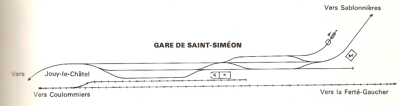
In Saint-Siméon operated the Sablonnières – Nangis railway from 1903 to 1914, the small meter- gauge railway of the Société des chemins de fer Economiques de Seine-et-Marne .
Individual evidence
- ↑ SNCF Region de l'Est. Carnet de profils et schémas, 1962, page 87
- ^ A b François and Maguy Palau: Le rail en France, Volume II, 1858–1863, Paris 2001, ISBN 2-950-94212-1
- ↑ Situation de la gare de Saint-Siméon , track plan Le carnet du CFC . La gare de St Siméon (Seine-et-Marne)
- ↑ Le carnet du CFC . History of the Société des chemins de fer Economiques de Seine-et-Marne (French)