
La Ferté-Gaucher
| La Ferté-Gaucher | ||
|---|---|---|

|
|
|
| region | Île-de-France | |
| Department | Seine-et-Marne | |
| Arrondissement | Provins | |
| Canton | Coulommiers | |
| Community association | Deux Morin | |
| Coordinates | 48 ° 47 ' N , 3 ° 18' E | |
| height | 107-188 m | |
| surface | 17.32 km 2 | |
| Residents | 4,860 (January 1, 2017) | |
| Population density | 281 inhabitants / km 2 | |
| Post Code | 77320 | |
| INSEE code | 77182 | |
| Website | www.la-ferte-gaucher.org | |
 Saint-Romain church in La Ferté-Gaucher |
||

La Ferte-Gaucher is a French municipality with 4860 inhabitants (as of January 1 2017) in the department of Seine-et-Marne in the region Ile-de-France . It belongs to the Arrondissement Provins in the canton of Coulommiers . The inhabitants are called Fertois .
geography
The municipality of La Ferté-Gaucher is located on the Grand Morin River , about 20 kilometers east of Coulommiers , about 30 kilometers northeast of Provins and 80 kilometers east of Paris .
Population development
| year | 1946 | 1954 | 1962 | 1968 | 1975 | 1982 | 1990 | 1999 | 2006 | 2011 |
| Residents | 2.176 | 2,019 | 2,585 | 3,258 | 3,821 | 3,871 | 3,924 | 4,150 | 4,057 | 4,557 |
Attractions
See also: List of Monuments historiques in La Ferté-Gaucher
- Remains of the former Saint-Martin priory chapel from the 11th century
- Parish Church of Saint-Romain
- Market hall , built between 1880 and 1882
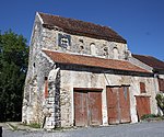
Former Saint Martin chapel

Parish Church of Saint-Romain


Community partnerships
- Bedburg-Hau (since 1990)
Personalities
- Noël Forgeard (* 1946), CEO of the Airbus Group from 2005 to 2006
literature
- Le Patrimoine des Communes de la Seine-et-Marne. Flohic Editions, Volume 1, Paris 2001, ISBN 2-84234-100-7 , pp. 511-515.
Web links
Commons : La Ferté-Gaucher - Collection of images, videos and audio files
Individual evidence
- ↑ Profile of La Ferté-Gaucher ( French ) Retrieved July 27, 2014.