Melz-sur-Seine
| Melz-sur-Seine | ||
|---|---|---|
|
|
||
| region | Île-de-France | |
| Department | Seine-et-Marne | |
| Arrondissement | Provins | |
| Canton | Provins | |
| Community association | Provinois | |
| Coordinates | 48 ° 30 ′ N , 3 ° 25 ′ E | |
| height | 58-172 m | |
| surface | 18.50 km 2 | |
| Residents | 352 (January 1, 2017) | |
| Population density | 19 inhabitants / km 2 | |
| Post Code | 77171 | |
| INSEE code | 77289 | |
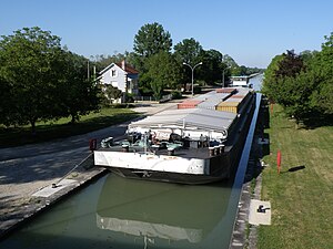
 Shipping lock at Melz-sur-Seine |
||
Melz-sur-Seine is a French commune in the Seine-et-Marne department in Île-de-France with over 350 inhabitants. It belongs to the canton of Provins (until 2015 the canton of Villiers-Saint-Georges ) in the Provins arrondissement .
geography
Melz-sur-Seine is located north of the Seine and is touched by this river on a short section in the southeast. The Canal de dérivation de Beaulieu à Villiers-sur-Seine and the Paris – Mulhouse railway line run through the municipal marker . Neighboring municipalities are Sourdun in the north, Saint-Nicolas-la-Chapelle in the northeast, Le Mériot and La Motte-Tilly in the southeast, Courceroy in the south, Villiers-sur-Seine in the southwest and Hermé in the west. The municipality covers an area of 18.50 km² .
Population development
| year | 1962 | 1968 | 1975 | 1982 | 1990 | 1999 | 2008 | 2014 |
|---|---|---|---|---|---|---|---|---|
| Residents | 254 | 214 | 193 | 247 | 278 | 339 | 379 | 365 |
Attractions
- Former Gallo-Roman fortress
- Saint-Phal church
literature
- Le Patrimoine des Communes de la Seine-et-Marne. Flohic Editions, Volume 2, Paris 2001, ISBN 2-84234-100-7 , pp. 1483-1484.
