
Le Mériot
| Le Mériot | ||
|---|---|---|
|
||
| region | Grand Est | |
| Department | Aube | |
| Arrondissement | Nogent-sur-Seine | |
| Canton | Nogent-sur-Seine | |
| Community association | Nogentais | |
| Coordinates | 48 ° 30 ' N , 3 ° 26' E | |
| height | 59-184 m | |
| surface | 12.60 km 2 | |
| Residents | 614 (January 1, 2017) | |
| Population density | 49 inhabitants / km 2 | |
| Post Code | 10400 | |
| INSEE code | 10231 | |

Le Mériot is a French commune with 614 inhabitants (as of January 1, 2017) in the Aube department in the Grand Est region . The place belongs to the arrondissement of Nogent-sur-Seine and the canton of Nogent-sur-Seine . The community is also part of the Nogentais community association founded in 2006 . The inhabitants are called Mériotins / Mériotines .
geography
Le Mériot is located around 52 kilometers northwest of Troyes and around 89 kilometers southeast of Paris in the north-west of the Aube department on the border with the Seine-et-Marne department . The municipality consists of the villages of Beaulieu, Le Mériot and Le Plessis Mériot and is largely covered by forest. The Seine forms large parts of the southern municipal boundary .
Neighboring communities are Chalautre-la-Grande (in the Seine-et-Marne department) in the north, Saint-Nicolas-la-Chapelle in the east, Nogent-sur-Seine in the south-east, La Motte-Tilly in the south-west and Melz-sur-Seine ( in the Seine-et-Marne department) to the west.
history
Until the French Revolution, Le Mériot was within the province of Champagne . The parish belonged to the district of Nogent-sur-Seine from 1793 to 1801. Since 1801 it has been assigned to the Arrondissement of Nogent-sur-Seine. The municipality has been within the canton of Nogent-sur-Seine since 1793. The municipality used to be called Le Meriol .
Population development
| year | 1793 | 1800 | 1846 | 1856 | 1886 | 1911 | 1921 | 1962 | 1968 | 1975 | 1982 | 1990 | 1999 | 2006 | 2012 |
| Residents | 549 | 624 | 620 | 543 | 613 | 423 | 350 | 336 | 325 | 339 | 356 | 417 | 495 | 550 | 589 |
| Sources: Cassini and INSEE | |||||||||||||||
Attractions
- Bridge Ponts de la route royale Paris-Bâle (built in the 1740s), a monument historique since 1993
- Dam road and arch bridges at Château de Jaillac (17th / 18th century), a monument historique since 1996
- Saints-Pierre-et-Paul village church
- Lock on the Canal de Dérivation de Beaulieu à Villiers-sur-Seine
- Memorial to the Fallen

The four arch bridges at the Château de Jaillac
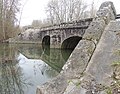
Ponts de la route royale Paris-Bâle
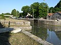
Beaulieu lock


Web links
- Location of the municipality
- Brief information about the community
- Le Mériot on the IGN site
- Photos of the Saints-Pierre-et-Paul church