
Saint-Loup-de-Buffigny
| Saint-Loup-de-Buffigny | ||
|---|---|---|
|
||
| region | Grand Est | |
| Department | Aube | |
| Arrondissement | Nogent-sur-Seine | |
| Canton | Saint-Lyé | |
| Community association | L'Orvin et de l'Ardusson | |
| Coordinates | 48 ° 27 ' N , 3 ° 38' E | |
| height | 89-156 m | |
| surface | 10.16 km 2 | |
| Residents | 210 (January 1, 2017) | |
| Population density | 21 inhabitants / km 2 | |
| Post Code | 10100 | |
| INSEE code | 10347 | |
| Website | https://saint-loup-de-buffigny.fr/ | |
 Town hall (Mairie) of Saint-Loup-de-Buffigny |
||

Saint-Loup-de-Buffigny is a French commune with 210 inhabitants (as of January 1, 2017) in the Aube department in the Grand Est region (before 2016 Champagne-Ardenne ); it belongs to the arrondissement of Nogent-sur-Seine and the canton of Saint-Lyé (until 2015 Romilly-sur-Seine-1 ).
geography
Saint-Loup-de-Buffigny is about 32 kilometers northwest of Troyes . Saint-Loup-de-Buffigny is surrounded by the neighboring communities of Saint-Hilaire-sous-Romilly in the north, Gélannes in the north and north-east, Saint-Martin-de-Bossenay and La Fosse-Corduan in the east, and Rigny-la-Nonneuse in the south and south-east, Avant-lès-Marcilly to the west and south-west, and Ferreux-Quincey to the west.
Population development
| year | 1962 | 1968 | 1975 | 1982 | 1990 | 1999 | 2006 | 2011 | 2016 |
| Residents | 150 | 137 | 141 | 154 | 161 | 164 | 176 | 204 | 214 |
| Source: Cassini and INSEE | |||||||||
Attractions
- Menhir Pierreà l'Abbé , Monument historique since 1993
- Saint-Loup-de-Troyes church from the 12th century

Menhir
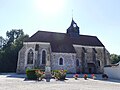
Saint-Loup-de-Troyes church
.jpg)

Web links
Commons : Saint-Loup-de-Buffigny - Collection of images, videos and audio files