
Saint-Oulph
| Saint-Oulph | ||
|---|---|---|
|
||
| region | Grand Est | |
| Department | Aube | |
| Arrondissement | Nogent-sur-Seine | |
| Canton | Creney-près-Troyes | |
| Community association | Seine et Aube | |
| Coordinates | 48 ° 31 ' N , 3 ° 52' E | |
| height | 78-93 m | |
| surface | 10.84 km 2 | |
| Residents | 287 (January 1, 2017) | |
| Population density | 26 inhabitants / km 2 | |
| Post Code | 10170 | |
| INSEE code | 10356 | |
 Mairie Saint-Oulph |
||

Saint-Oulph is a French commune with 287 inhabitants (as of January 1, 2017) in the Aube department in the Grand Est region (until 2015 Champagne-Ardenne ). The municipality belongs to the arrondissement of Nogent-sur-Seine and to the community association Seine et Aube, founded in 2016 . The inhabitants are called Saint-Oulphiens .
geography
The municipality of Saint-Oulph is located on the Seine , 30 kilometers northwest of Troyes and about 100 kilometers east of the metropolitan area of Paris . The Seine meanders strongly here and is accompanied in its wide alluvial forest by several watercourses, oxbow lakes and the Canal de la Haute Seine , which is still of touristic importance. In contrast to the humid Seine valley is the northeastern adjoining Champagne sèche , the "dry Champagne", which is characterized by large fields and does not allow viticulture. The terrain of the 10.94 km² community is mostly flat. In the northwest, the municipality borders on the Marne department . Saint-Oulph is surrounded by the neighboring municipalities of Étrelles-sur-Aube in the north, Longueville-sur-Aube in the northeast, Méry-sur-Seine in the southeast, Châtres in the southwest and Clesles in the west.
Population development
| year | 1962 | 1968 | 1975 | 1982 | 1990 | 1999 | 2009 | 2016 | |
| Residents | 181 | 170 | 147 | 169 | 173 | 192 | 217 | 281 | |
| Sources: Cassini and INSEE | |||||||||
Attractions
- Saint-Oulph church with the tomb of the Chevalier Frédérik de Saint-Oulph and a Gallo-Roman sarcophagus
- several hall crosses
- Water tower
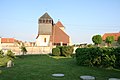
Saint-Oulph church
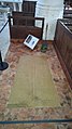
The grave of Chevalier Frédérik de Saint-Oulph, who died in 1272, in the church

Gallo-Roman sarcophagus at the entrance to the church

.jpg)

Economy and Infrastructure
In Saint-Oulph there are three farms and three farms (cereal, oilseed and fodder cultivation).
The D 373 from Sézanne to Troyes runs through the municipality of Saint-Oulph . In the municipality of Torcy-le-Grand , 22 kilometers to the east, there is a connection to the A 26 autoroute from Châlons-en-Champagne to Troyes.
supporting documents
- ↑ Saint-Oulph on cassini.ehess.fr
- ↑ Saint-Oulph on insee.fr
- ↑ Forestry operations on annuaire-mairie.fr (French)
- ↑ Farms on annuaire-mairie.fr (French)