
Marcilly-le-Hayer
| Marcilly-le-Hayer | ||
|---|---|---|

|
|
|
| region | Grand Est | |
| Department | Aube | |
| Arrondissement | Nogent-sur-Seine | |
| Canton | Saint-Lyé | |
| Community association | Orvin and Ardusson | |
| Coordinates | 48 ° 21 ' N , 3 ° 38' E | |
| height | 113-266 m | |
| surface | 34.34 km 2 | |
| Residents | 725 (January 1, 2017) | |
| Population density | 21 inhabitants / km 2 | |
| Post Code | 10290 | |
| INSEE code | 10223 | |

Marcilly-le-Hayer is a French commune with 725 inhabitants (as of January 1, 2017) in the Aube department in the Grand Est region ; it belongs to the arrondissement of Nogent-sur-Seine and the canton of Saint-Lyé (until 2015: canton of Marcilly-le-Hayer ).
geography
Marcilly-le-Hayer is about 33 kilometers west-northwest of Troyes on the Orvin . Marcilly-le-Hayer is surrounded by the neighboring communities of Avon-la-Pèze in the north, Saint-Lupien in the east and northeast, Villadin in the east and southeast, Aix-Villemaur-Pâlis in the southeast, Planty in the south, Pouy-sur-Vannes in the Southwest, Bercenay-le-Hayer in the west and Bourdenay in the northwest.
Population development
| year | 1962 | 1968 | 1975 | 1982 | 1990 | 1999 | 2006 | 2013 |
| Residents | 512 | 464 | 471 | 582 | 630 | 702 | 677 | 709 |
| Source: Cassini and INSEE | ||||||||
Attractions
- Dolmen La Pierre Couverte by Vamprin and Les Blancs Fossés and Megalithe, Monuments historiques since 1936 and 1959
- Saint-Leu-de-Sens church, a historic monument since 1977
- Saint-Flavit Chapel, built in 1897
- Chavaudon Castle from 1913

Dolmen Le Vamprin

Saint-Leu-de-Sens church
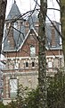
Chavaudon Castle

_%C3%89glise_Saint-Leu-de-Sens.jpg)

Web links
Commons : Marcilly-le-Hayer - collection of pictures, videos and audio files