Saint-Ouen-sur-Morin
| Saint-Ouen-sur-Morin | ||
|---|---|---|
|
|
||
| region | Île-de-France | |
| Department | Seine-et-Marne | |
| Arrondissement | Provins | |
| Canton | Coulommiers | |
| Community association | Deux Morin | |
| Coordinates | 48 ° 54 ' N , 3 ° 11' E | |
| height | 61-187 m | |
| surface | 3.79 km 2 | |
| Residents | 536 (January 1, 2017) | |
| Population density | 141 inhabitants / km 2 | |
| Post Code | 77750 | |
| INSEE code | 77429 | |
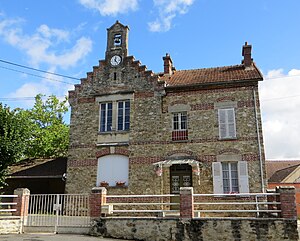
 Town hall (Mairie) of Saint-Ouen-sur-Morin |
||
Saint-Ouen-sur-Morin is a French municipality with 536 inhabitants (as of January 1 2017) in the department of Seine-et-Marne in the region Ile-de-France . It belongs to the Arrondissement Provins and is part of the canton of Coulommiers (until 2015: canton of Rebais ). Their inhabitants are called Audonniens .
geography
Saint-Ouen-sur-Morin is located about 63 kilometers east of Paris on the Petit Morin . Saint-Ouen-sur-Morin is surrounded by the neighboring communities of Saint-Cyr-sur-Morin in the north and west, Bussières in the northeast, Orly-sur-Morin in the east and Doue in the south.
Population development
| 1962 | 1968 | 1975 | 1982 | 1990 | 1999 | 2006 | 2012 |
|---|---|---|---|---|---|---|---|
| 199 | 208 | 265 | 337 | 479 | 537 | 576 | 553 |
| Source: Cassini and INSEE | |||||||
Attractions
- Remains of the La Brosse castle
- Wash house
literature
- Le Patrimoine des Communes de la Seine-et-Marne. Volume 2. Flohic Editions, Paris 2001, ISBN 2-84234-100-7 , pp. 1305-1306.
Web links
Commons : Saint-Ouen-sur-Morin - Collection of images, videos and audio files

