
Pécy
| Pécy | ||
|---|---|---|
.svg)
|
|
|
| region | Île-de-France | |
| Department | Seine-et-Marne | |
| Arrondissement | Provins | |
| Canton | Fontenay-Trésigny | |
| Community association | Val Briard | |
| Coordinates | 48 ° 39 ′ N , 3 ° 5 ′ E | |
| height | 109-145 m | |
| surface | 21.07 km 2 | |
| Residents | 863 (January 1, 2017) | |
| Population density | 41 inhabitants / km 2 | |
| Post Code | 77970 | |
| INSEE code | 77357 | |

Pécy is a French commune in the Seine-et-Marne in the Ile-de-France . It belongs to the canton of Fontenay-Trésigny in the Provins arrondissement . It borders on Voinsles to the north-west, Vaudoy-en-Brie to the north, Jouy-le-Châtel to the east, Saint-Just-en-Brie to the south-east, La Croix-en-Brie to the south and Gastins to the south-west . In addition to the main settlement, Pécy also includes the hamlets of Mélenfroy, Beaulieu, La Faultière, Ferme de la Cour, Champmoulin and Bois Garnier.
Population development
| year | 1962 | 1968 | 1975 | 1982 | 1990 | 1999 | 2008 | 2014 |
|---|---|---|---|---|---|---|---|---|
| Residents | 336 | 315 | 330 | 425 | 565 | 677 | 821 | 843 |
Attractions
See also: List of the Monuments historiques in Pécy
- Church of Sainte-Marie-Madeleine, monument historique since 1909
- Former castle from the 16th century
- Pigeon house

Sainte-Marie-Madeleine church
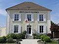
Mairie (Town Hall)
_%C3%89glise.jpg)
_Mairie.jpg)
literature
- Le Patrimoine des Communes de la Seine-et-Marne. Flohic Editions, Volume 2, Paris 2001, ISBN 2-84234-100-7 , pp. 1112-1115.
Web links
Commons : Pécy - collection of images, videos and audio files