
Égligny
| Égligny | ||
|---|---|---|
|
||
| region | Île-de-France | |
| Department | Seine-et-Marne | |
| Arrondissement | Provins | |
| Canton | Provins | |
| Community association | Bassée-Montois | |
| Coordinates | 48 ° 26 ' N , 3 ° 7' E | |
| height | 50-135 m | |
| surface | 16.58 km 2 | |
| Residents | 331 (January 1, 2017) | |
| Population density | 20 inhabitants / km 2 | |
| Post Code | 77126 | |
| INSEE code | 77167 | |
 Mairie and Schoolhouse |
||

Égligny is a French commune in the Seine-et-Marne in the Ile-de-France . It belongs to the canton of Provins (until 2015 canton Donnemarie-Dontilly ) in the Arrondissement of Provins . It borders on Montigny-Lencoup and Gurcy-le-Châtel in the north -west , Donnemarie-Dontilly in the north, Vimpelles in the east, Balloy in the south-east and Châtenay-sur-Seine in the south-west . The inhabitants call themselves Églignyciens . The center of the village is 59 meters above sea level.
history
In 1118 the Preuilly monastery was founded in Égligny .
The church of Saint-Martin et Saint-Félicien is declared a Monument historique .

Ruin of the monastery church
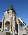
Saint-Martin et Saint-Félicien church


Population development
| year | 1962 | 1968 | 1975 | 1982 | 1990 | 1999 | 2008 | 2014 |
|---|---|---|---|---|---|---|---|---|
| Residents | 309 | 274 | 214 | 199 | 237 | 275 | 330 | 324 |
Architectural monuments
See: List of Monuments historiques in Égligny
literature
- Le Patrimoine des Communes de la Seine-et-Marne. Flohic Editions, Volume 1, Paris 2001, ISBN 2-84234-100-7 , pp. 454-457.
Web links
Commons : Égligny - Collection of images, videos and audio files