
Gurcy-le-Châtel
| Gurcy-le-Châtel | ||
|---|---|---|
|
||
| region | Île-de-France | |
| Department | Seine-et-Marne | |
| Arrondissement | Provins | |
| Canton | Provins | |
| Community association | Bassée-Montois | |
| Coordinates | 48 ° 28 ' N , 3 ° 6' E | |
| height | 94-149 m | |
| surface | 12.59 km 2 | |
| Residents | 573 (January 1, 2017) | |
| Population density | 46 inhabitants / km 2 | |
| Post Code | 77520 | |
| INSEE code | 77223 | |
 Mairie Gurcy-le-Châtel |
||

Gurcy-le-Chatel is a French commune in the Seine-et-Marne in the Ile-de-France . It belongs to the canton of Provins in the Arrondissement of Provins . It borders in the north on Meigneux , in the east on Donnemarie-Dontilly , in the south-east on Égligny , in the south-west on Montigny-Lencoup and in the north-west on Villeneuve-les-Bordes . The residents call themselves Gurcyssois .
Population development
| year | 1962 | 1968 | 1975 | 1982 | 1990 | 1999 | 2008 | 2014 |
|---|---|---|---|---|---|---|---|---|
| Residents | 468 | 430 | 409 | 393 | 352 | 384 | 535 | 574 |

lock
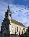
Saint-Jacques-le-Majeur church


Attractions
See: List of Monuments historiques in Gurcy-le-Châtel
literature
- Le Patrimoine des Communes de la Seine-et-Marne. Flohic Editions, Volume 1, Paris 2001, ISBN 2-84234-100-7 , pp. 458-459.
Web links
Commons : Gurcy-le-Châtel - collection of images, videos and audio files