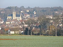
Donnemarie-Dontilly
| Donnemarie-Dontilly | ||
|---|---|---|

|
|
|
| region | Île-de-France | |
| Department | Seine-et-Marne | |
| Arrondissement | Provins | |
| Canton | Provins | |
| Community association | Bassée-Montois | |
| Coordinates | 48 ° 29 ' N , 3 ° 8' E | |
| height | 68-139 m | |
| surface | 12.07 km 2 | |
| Residents | 2,832 (January 1, 2017) | |
| Population density | 235 inhabitants / km 2 | |
| Post Code | 77520 | |
| INSEE code | 77159 | |
| Website | http://www.donnemarie-dontilly.fr/ | |
 Town hall of Donnemarie-Dontilly |
||
Donnemarie-Dontilly is a French commune with 2,832 inhabitants (as of January 1 2017) in the department of Seine-et-Marne in the region Ile-de-France . It belongs to the district of Provins of the Canton of Provins . The inhabitants are called Donnemaritains .
geography
Donnemarie-Dontilly is located on the Auxence River . Donnemarie-Dontilly is surrounded by the neighboring communities of Meigneux in the north and north-west, Mons-en-Montois in the north and north-east, Sigy in the east, Vimpelles in the south-east, Égligny in the south and Gurcy-le-Châtel in the west.
The former Route nationale 375 runs through the municipality .
history
In 1967 the formerly independent municipalities of Donnemarie and Dontilly were combined to form today's municipality.
Population development
| 1962 | 1968 | 1975 | 1982 | 1990 | 1999 | 2006 | 2012 |
|---|---|---|---|---|---|---|---|
| 963 | 1,668 | 1,809 | 1,845 | 2,295 | 2,628 | 2,744 | 2,876 |
Attractions
See also: List of Monuments historiques in Donnemarie-Dontilly
- Church Notre-Dame-de-la-Nativité from 12-13. Century, since 1846 Monument historique
- Church Saint-Pierre in Dontilly from 11-12. Century, restored at the end of the 15th century, Monument historique
- town hall
- Wash house , built in the 19th century
Personalities
- Gérard Presgurvic (* 1953), composer
literature
- Le Patrimoine des Communes de la Seine-et-Marne. Flohic Editions, Volume 1, Paris 2001, ISBN 2-84234-100-7 , pp. 447-453.
Web links
- Donnemarie-Dontilly at annuaire-mairie.fr (French)


