
Meilleray
| Meilleray | ||
|---|---|---|
|
||
| region | Île-de-France | |
| Department | Seine-et-Marne | |
| Arrondissement | Provins | |
| Canton | Coulommiers | |
| Community association | Deux Morin | |
| Coordinates | 48 ° 47 ' N , 3 ° 26' E | |
| height | 107-188 m | |
| surface | 7.77 km 2 | |
| Residents | 501 (January 1, 2017) | |
| Population density | 64 inhabitants / km 2 | |
| Post Code | 77320 | |
| INSEE code | 77287 | |
 Town hall ( mairie ) |
||

Meilleray is a French municipality with 501 inhabitants (as of January 1 2017) in the department of Seine-et-Marne in the region Ile-de-France . It belongs to the Arrondissement Provins and the Canton of Coulommiers . The inhabitants are called Meillerassiens .
geography
The municipality of Meilleray is about nine kilometers east of La Ferté-Gaucher , 29 kilometers east of Coulommiers , 27 kilometers north of Provins and 90 kilometers east of Paris .
Population development
| year | 1936 | 1946 | 1954 | 1962 | 1968 | 1975 | 1982 | 1990 | 1999 | 2006 | 2011 |
| Residents | 401 | 410 | 395 | 394 | 354 | 462 | 385 | 363 | 398 | 475 | 511 |
Attractions
- Parish Church of Saint-Pierre-Saint-Paul
- old trainstation
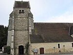
Saint-Pierre-Saint-Paul Church
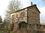
Former train station


literature
- Le Patrimoine des Communes de la Seine-et-Marne. Flohic Editions, Volume 1, Paris 2001, ISBN 2-84234-100-7 , pp. 521-522.
Web links
Commons : Meilleray - collection of images, videos and audio files
Individual evidence
- ^ Profile of Meilleray ( French ) Retrieved August 4, 2014.